

How big is the network and who funds it?
The Network of the Americas (NOTA) includes around 1,200 GNSS and borehole stations stretching from Alaska to the Caribbean. It is funded by the U.S. National Science Foundation as part of its National Geophysical Facility. EarthScope Consortium is the operator of this facility, and EarthScope staff maintain the stations, run the data archive, and support the community of university and government researchers that use the network for their science.
What’s the difference between GPS and GNSS?
You will see two terms used to describe these instruments: GPS and GNSS. The first is likely familiar, but the second may not be. GPS stands for “Global Positioning System”, while GNSS stands for “Global Navigation Satellite System”. At a simple level, you can think of these terms as referring to the same thing. There are several GNSS constellations and the United-States-run GPS is one of them. Technically speaking, some older devices can only use the GPS constellation, while others can use multiple constellations ― hence we call them GNSS devices, instead.
What do scientists do with this data?
Many things! A few brief examples:
- These stations can measure the slow, gradual movement of tectonic plates as they creep along at about an inch per year. It’s this motion that accumulates stress in seismically active areas, eventually leading to earthquakes. >Tectonic motion poster
- GNSS stations are also useful when earthquakes occur nearby. They help us measure how much faults moved, which is critical information for multiple reasons. One is that this is used to calculate how much stress was relieved from the fault, affecting of understanding of where seismic risk is currently high. The other benefit is that GNSS stations contribute to the Shakealert® Earthquake Early Warning System on the US West Coast, significantly improving performance for the largest and most dangerous earthquakes. >Read more
- Volcanic activity is another hazard that GNSS stations help us monitor. Volcanoes can “breathe” as magma moves around inside them, causing their slopes to rise and fall. Measuring this movement is one key to understanding their behavior and alerting nearby communities when an eruption could be imminent. NOTA stations are part of the monitoring networks for Mount St. Helens and Yellowstone. >Read more
- Other interesting things can be done with satellite signals that bounce off the ground before reaching the GNSS station’s antenna. This can be used to measure changing depth of snow around the station, or water levels if the station is along a lake or the ocean. And with a variation on this technique, it can even be used to measure soil moisture. >Read more
- Believe it or not, the surface of the Earth can move up and down in response to changes in water resources. By precisely measuring that movement in many places, we can estimate how much water was gained or lost from groundwater aquifers or even from surface water in an area. By combining GNSS data with other techniques ― like InSAR satellites, GRACE satellites, seismic data, well data, and more ― we can develop a complete understanding of our water resources. >Read more
- Because space weather ― activity in Earth’s ionosphere ― interferes with the signal from navigation satellites, techniques have been developed to minimize this source of error in position measurements. That means GNSS stations can also be used to monitor and measure space weather. >Read more
- Like space weather, water vapor in Earth’s lower atmosphere also affects the signal from navigation satellites, leading to techniques that quantify this source of error and make position data more precise. GNSS stations provide a unique measurement of the total amount of water vapor between the station and the satellite. For this reason, they are among the sources of atmospheric data used in major weather forecast models. >Read more
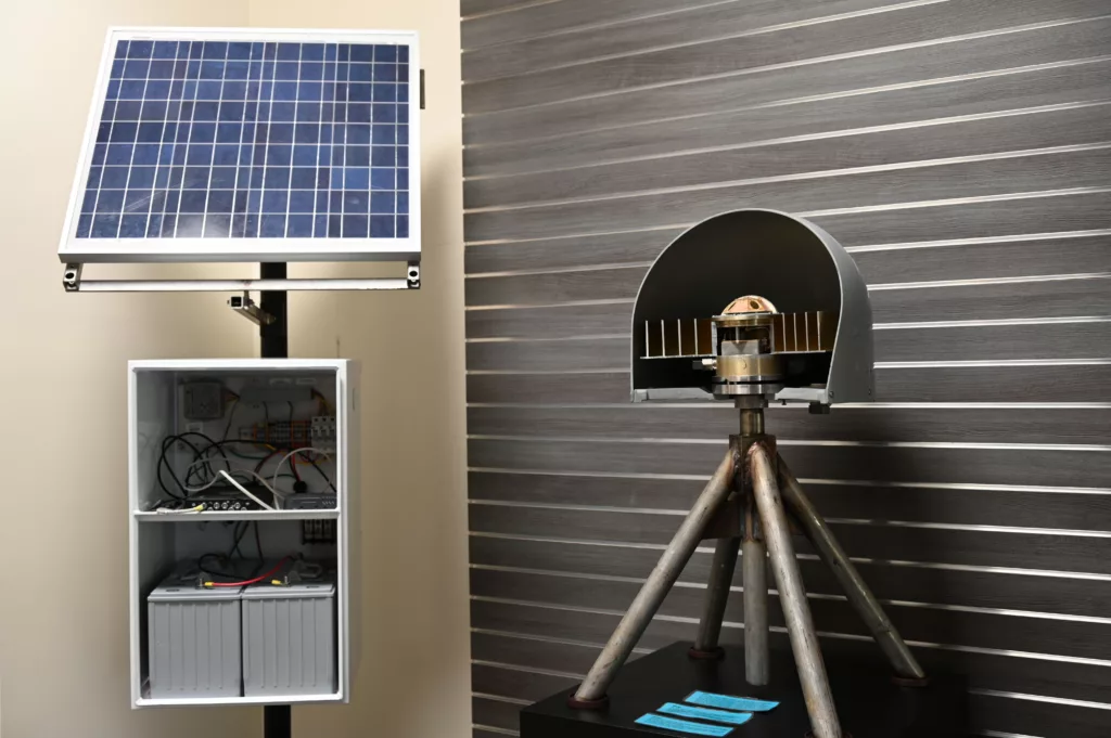
What equipment is present at a NOTA station?
The enclosure box with the solar panels includes batteries, charging controls, and two key devices. One is the GNSS receiver, which records the satellite signals, calculates the station’s position, and stores this data. The other is responsible for transmitting the data back to our archive ― sometimes this is a cell modem, sometimes it is a satellite connection (such as Starlink), and sometimes it is a radio.
The part of the station that looks like a gray ball on a tripod is the GNSS antenna. Inside the plastic dome is a special circular antenna designed to maximize the signal from navigation satellites. It is mounted on steel legs that are anchored securely into the ground. This is the where the station’s position ― and the movement of the ground ― is measured. A cable connects this antenna to the GNSS receiver inside the enclosure box.
Any vegetation or objects around the antenna can interfere with the incoming satellite signal, reducing data quality. Locations are chosen to maximize their unobstructed sky view, but maintenance visits sometimes involve trimming opportunistic bushes that have grown up around the antenna.
Some stations include other instruments, like meteorological packs. A smaller number of NOTA stations feature strainmeter instruments in a borehole.
How do NOTA stations measure the movement of the Earth so precisely?
Like any GPS/GNSS device, NOTA stations use information from navigation satellites to calculate their exact location. These satellites constantly transmit precisely timestamped messages, and the difference between that time and the time a device receives that message is used to calculate how far away that satellite must be. Using this information for four or more satellites, a GPS/GNSS receiver can resolve its location on Earth’s surface.
But while your cell phone can resolve its location within about 3 meters (or 10 feet), NOTA stations measure location to within about a centimeter (less than half an inch). It does this by going beyond the information in the navigation satellite’s message ― it uses the radio waves carrying that message.
Radio waves oscillate at a certain frequency, and this is used to transmit the binary bits that can encode text and other data. It takes many oscillations to transmit an entire sentence. NOTA stations count each oscillation as they read that message. Imagine the satellite’s message is written on a meter-long stick of wood. This might allow us to figure out how many meters away we are from the satellite. But if we added centimeter and millimeter ticks on that stick, like a meter ruler, we can measure our distance more precisely.
Where does the data from a NOTA station go?
Data streaming from these stations is stored in the NSF National Geophysical Facility data archive. The archive is open and accessible to all, including researchers, educators, other professionals, hobbyists, and commercial entities that license the data for use in services they offer. Users just need to create a free account and log in.
Where can I see the data?
The data are stored in a technically complex format, but we also have some tools that make it easy to see simplified information. Our Velocity Viewer map shows the long-term rate and direction each station is moving horizontally. Our Network Monitoring map shows where all NOTA stations are located, and allows you to click on each one for more information, including a simple plot of location data in the north-south, east-west, and vertical directions.
What else can be done with this data?
Precision positioning has a number of applications, from surveying and construction to agriculture to autonomous vehicles. NOTA stations are excellent reference stations ― nearby GPS/GNSS devices onboard vehicles or used by surveyors can be much more accurate with their help. This works because common sources of noise in position data ― caused by space weather or water vapor in the atmosphere, for example ― are consistent over considerable areas. Because reference stations never move, they can be used to estimate that noise and remove it from your device, as well.
Additionally, permanent stations like those in NOTA are used in national and international efforts to maintain the coordinate system itself! The Earth is constantly changing, so making sure that a precise latitude and longitude refers to the exact same spot over the years requires us to carefully adjust the reference frame that underlies the coordinate system.