

Instrumentation
EarthScope Primary Instrument Center (EPIC)
EarthScope Primary Instrument Center (EPIC) loans a variety geophysics instruments for educational use in the USA. Instruments are available on a first-come-first-served basis.
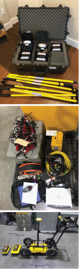
- GPS/GNSS surveying – teaching kits of Emlid Reach RS2/2+ real-time kinematic (RTK) receivers (typically 1 base, 4 rovers, and related survey supplies; but other configurations are possible)
- Multi-channel seismic refraction – Geodes, geophones, takeout cables, field laptop
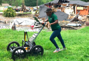
- Ground penetrating radar (GPR) – Noggin GPR, antennae (100, 250, 500, 1000 MHz available), field laptop, educational access to software
- Electrical resistivity tomography (ERT) – SuperSting R8, electrodes, cables, field laptop
- SfM supplies – ground control points, 4.5-meter telescoping SfM pole, camera
Requesting instruments from EPIC (formerly PASSCAL)
Requests go through the EPIC Experiment Scheduling Instrument Request Form. The first step is to set up your PI Account. This tutorial walks you through the general instrument request process but educational users can use the step-by-step guide below.
Show more about filling out the Instrument Request Form for educational requests
These bullets give step-by-step guidance for filling out the Instrument Request Form (once you have a PI Account).
- Experiment
- Experiment Name: It is helpful if you follow this general format — “Education: college-name course-name term”
- Ex. Education: Univ of Colorado Geomorphology spring 2024
- It is fine to have the Name and Long Name be the same
- Description: Description of what you plan to do with the instrument(s).
- Experiment Name: It is helpful if you follow this general format — “Education: college-name course-name term”
- Requested Instruments
- Dates: Dates the instruments will be away from EPIC. Factor ~3 business days of shipping time on either side.
- Requested Instrument
- GPS/GNSS
- Receiver > RTK-GNSS
- Typical teaching kit is 5 Emlid Reach RS2/2+ receivers (1 base, 4 rovers) but you can request a different number. You will also receive the standard poles, tripod, and other supplies needed.
- Seismic
- Datalogger > Multichannel
- Auxiliary > Multichannel Takeout Cables
- Educational users typically request 1. Some larger courses may ask for 2.
- Ground penetrating radar
- Datalogger > GPR Datalogger
- Sensor > GPR Antenna – Educational users typically request ~2 antennae so comparisons can be made between frequencies
- Receiver > RTK-GNSS – If you would like to have an additional GPS/GNSS to serve as a base station (this is in addition to the GPS/GNSS rover on the GPR) then your final location solutions can achieve sub-decimeter accuracy. If several meters of accuracy is sufficient, then you do not need to request an additional receiver for the base station.
- GPS/GNSS
- Note: Details of requested instruments can be adjusted later in communications with EarthScope staff, so the main thing is to outline your general need here.
- Collaborators: No need to add anyone else but you can if you wish. They also need to have a PI Account to be findable in the system.
- Funding
- Funded:
- If your institution has funding for shipping, you are “funded” – answer Yes
- If you attended an EarthScope (GETSI or IGUaNA) field education workshop and this is your first time requesting instruments, you are eligible for a waiver this time – answer Yes
- If you would like to request a waiver because you are at a low-resource institution and shipping costs would be a barrier, include this request in General Comments below – answer No
- Funding Date: today’s date
- Award#: NA
- USAP: leave blank
- Support Letter: No
- Funded:
- Agency
- Agency: University
- Program: Education
- Billing
- If you select “yes” this will default to whatever you entered when you made your PI Account. You can check this under “My account” > PI contact Information.
- If the best billing address is different than your contact info, select “No” and fill in the billing contact here.
- Experiment Support
- PASSCAL Field Support: No
- Computer Support: No (If you are borrowing a type of instrument that requires a computer to operate it, that would be included automatically and you would not need to separately request one. Some research PIs request a field computer for other purposes.)
- Field Coordination: No
- SSF Coordination: No
- International Shipping: No
- Location
- Map: Select a box roughly around the region where you intend to use the instruments (toggle between “hand” and “box” to move around and then select)
- Environment: Select the most appropriate choice
- Geographic location: Location or region you will work in
- General comment: This is a place for more comments as needed. It would help if you include the following topics, as relevant.
- What are the exact days you plan to using the instruments for both your own prep and the time with students? We will use this information to cross-check the dates you choose above.
- If you have flexibility in when you borrow the instruments, please give some information on the range of options that would work for you.
- Additional requests for specific instruments: (this can be adjusted later in communications with EarthScope staff)
- For GPS/GNSS – if you have a preference between traditional and quick tripod or any other specific requests about the model of Emlid or other supplies you receive, note that here too. If you would like structure from motion (SfM) supplies such as ground control points or telescoping pole, mention that too.
- For seismic – if you know about specific ancillaries such as strike plate or trigger-switch, you can mention that here.
- For GPR – if you know the antenna frequencies that you would like, indicate that.
- If you are at a low-resource institution and would like to request a shipping waiver or funds to support one-time purchase of supplies typically provided by the borrower such as 12-volt batteries, sledge hammer, and safety equipment, note that here.
- If you know your shipping address will be different than the billing address above, list it here.
Cost
EPIC instruments have no rental fee but users pay for shipping. Educational waivers are available for low-resource U.S. institutions or people who recently completed an educational short course with EarthScope and are borrowing instruments for the first time. Low-resource institutions may also request funds to support one-time purchase of supplies typically provided by the borrower such as 12-volt batteries, sledge hammer, and safety equipment.
Typical round-trip shipping costs within the USA are:
- GPS/GNSS – $225 (for 5 receivers), $125 (2 receivers)
- Seismic – ~$450-650
- GPR – ~$300-350
- ERT – ~$450-500
Other Geophysics Instruments
The Near-Surface Geophysics Center at the University of Wyoming has other instruments available for rent. Currently EarthScope only owns one ERT, so may not be able to meet all requests.
- ERT – SuperSting
- CG-5 MicroGravimeter
Requesting instruments from U of WY
U of WY ERT Rental Checklist 2024-09-27
Costs
Gravimeter equipment must be rented. Shipping costs also apply.
Teaching Resources
GEophysics Tools for Societal Issues (GETSI)
The Field Collection component of the GEophysics Tools for Societal Issues (GETSI) program, provides six modules related to geodesy and near-surface geophysics.
The GEophysics Tools for Societal Issues curriculum equips students to tackle real-world challenges—such as natural hazards, environmental management, urban planning, and climate change—by integrating geophysical data and data analysis methods into undergraduate education. Developed and rigorously tested by faculty teams and content experts, these materials emphasize practical, societally important applications of geophysics. Modules are ready for use in your undergraduate introductory and majors-level courses.
Available modules:
- SfM/TLS: Analyzing high resolution topography with TLS and SfM
- GPS/GNSS: High precision positioning with static and kinematic GPS/GNSS
- Seismic: Measuring depth to bedrock for an urban renewal project using seismic refraction
- ERT: Evaluating the health of an urban wetland using electrical resistivity
- GPR: Pipes, tree roots, or unmarked graves? Forensic geophysics using GPR
- Grav/Mag: Locating Subsurface Features using Gravity and Magnetics
Manuals/Guides
More complete guidance for using geophysics field methods can be found in the teaching modules – see “Teaching Resources” tab. Below the instrument and software manuals are pulled out separately for easier access.
GPS/GNSS
- Emlid ReachRS2/2+/3 Quick Start Guide – getting started in the field
- Emlid ReachRS2/2+/3 Instructor Guide – more detailed guidance for instructors or more advanced students
Seismic Refraction
- Instructor Guide to Seismic Surveying – presentation for instructor reference or sharing with students
- How to: Seismic Refraction Field Setup Video
- Seismic Survey Additional Guidance and Equipment List
- Geode Field Quick Start Guide – for equipment setup and data acquisition
- Seismic survey stacklog – data sheet example
- Pickwin Software Data Processing Guide – a bit easier to install and use, but limited to 15 sessions before license purchase
- Refrapy Software Data Processing Guide – more effort to install and use, but free open source
Ground Penetrating Radar (GPR)
- Instructor Guide to GPR Surveying – presentation for instructor reference or sharing with students
- How to: Ground Penetrating Radar Field Setup Video
- Noggin GPR Packing and Assembly Guide
- Noggin GPR Survey Guide
- EKKO Project Software Downloading Instructions – proprietary software available when using EarthScope instrument or for 14-day free trial (educational users can request longer free trial)
- EKKO Project Software Data Processing Guide
Electrical Resistivity
- Instructor Guide to ERT Surveying – presentation for instructor reference or sharing with students
- How to: Electrical Resistivity Field Setup Video
- SuperStingR8 ERT Quick-Start Guide
- ERT Survey Additional Guidance and Equipment List
- Electrode spacing table – makes it easy to position each electrode depending on survey spacing
- Example field notes – so students can see the type of survey metadata that is needed
- SuperStingR8 command files – command files for typical surveys; usually EarthScope instrument will come with these loaded
- ResiPy Software Installation Guide – free open source software
- ResiPy Software Data Processing Guide
Structure from Motion (SfM)
- SfM Guide for Instructors and Investigators – considerations for designing and executing a field survey
- SfM Field Methods Manual for Students – short version for students
- Controlling Sony Camera Remotely – for use on an SfM pole
- Agisoft MetaShape Software Data Processing Quick Guide – proprietary software for creating point clouds from photographs, but 30-day fully functional free trial licenses are available; educational pricing is also available
- Agisoft MetaShape Data Processing and Exploration Manual – longer and with more detail
- OpenDroneMap Software Data Processing Quick Guide – free open source with most of the same functionality as MetaShape
- CloudCompare Data Processing Guide – allows more sophisticated data processing of point clouds; free open source
- CloudCompare on MacOS .las conversion – some files need to be converted to a different .las version on MacOS
Instructor Professional Development
EarthScope periodically offers workshops and webinars for instructors on topics related to teaching with geophysics data and instruments.
- Upcoming and Past workshops and short courses
- Learn about upcoming opportunities by joining the Teaching Geophysics Interest List. Send a blank email to teaching-geophysics+subscribe@earthscope.org
If you have any questions on educational use of geophysics field methods or instrumentation please reach out to education@earthscope.org
If you would like to join the Teaching Geophysics Interest Group, send a blank email to teaching-geophysics+subscribe@earthscope.org.
This moderated email group occasionally sends out announcements of resources, workshops, or other opportunities related to teaching geophysics.