

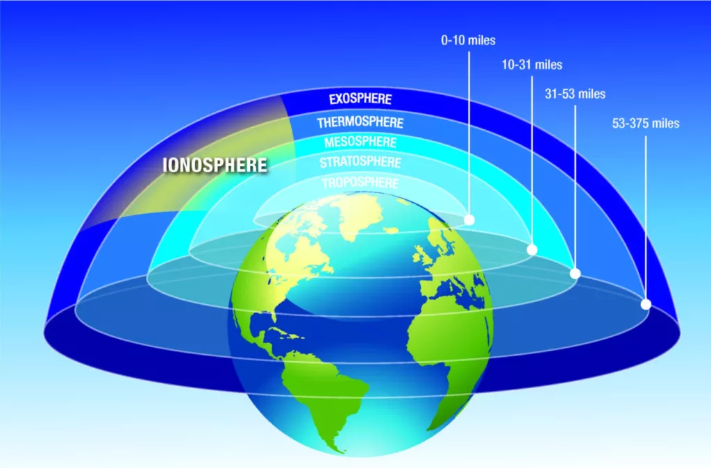
The ionosphere—a portion of Earth’s atmosphere that is largely made up of ionized particles—is responsible for some of the largest errors in GPS measurements. GPS receivers calculate the distances between themselves and satellites based on the difference in signal broadcast time and signal arrival time. In the ionosphere, though, the signal gets refracted due to the many free electrons present there. This changes the signal’s speed, delaying its arrival at the receiver. That increases the calculated distance, greatly reducing the accuracy of location measurements.
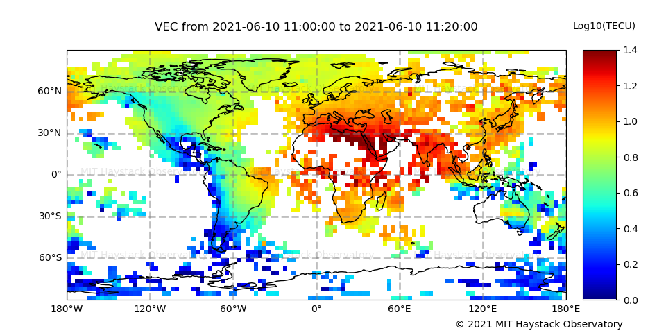
Because sunlight ionizes gas molecules to produce free electrons in the atmosphere, the density of these electrons cycles daily—the concentration is lowest between (local) midnight and early morning and then highest between noon and early afternoon. Similarly, the density of free electrons varies with the seasons and with solar cycles. But the ionosphere is also highly sensitive to coronal mass ejections from unpredictable solar flares—what is often referred to as “space weather”.
With so much variation in ionospheric activity over time and space, there is no consistent correction that can be applied for the ionosphere in GPS data. So how can we correct this source of error?
One way is to take advantage of the fact that higher frequency signals are slightly less affected by ionospheric activity than lower frequency signals. Since GPS satellites transmit on multiple frequencies, some receivers can use this difference to estimate and remove the impact of the ionosphere.
Most GPS users are primarily concerned with removing the ionospheric error, but the resulting estimate of total electron content can also be used as its own data product—to monitor space weather events that can disrupt communication signals of many kinds, for example.
Even the shadow cast during a solar eclipse perturbs the ionosphere. GPS-derived data can be used to investigate the behavior of the ionosphere during these unique events, improving our understanding of important processes like the ionosphere’s electrical energy flow between the Northern and Southern hemispheres. For example, GPS stations were used to record an Antarctic solar eclipse in December, 2021, which was particularly interesting because of its proximity to the South Pole.
The ionosphere can also be perturbed from below, by atmospheric motion that propagates upward. This includes tsunamis, which generate subtle atmospheric gravity waves as they travel across the ocean. As a result, the wave of ionospheric disturbance can be used to detect the tsunami—an opportunity that is motivating research into the use of GPS stations for tsunami detection. Because GPS-derived total electron content measurements sample the path between the satellite and the station, stations located on the coast can measure ionospheric disturbances over the ocean using satellites in that portion of the sky. This means GPS stations could supplement the seafloor pressure sensors that are located relatively close to the coast.