


You rely on your GPS devices to give you your coordinates, or to display your position directly on a map. But how do we define that coordinate system, particularly on a constantly changing planet, so that your coordinates precisely match up with the real world? And for that matter, how does a GPS satellite whizzing around the Earth know its own position so exactly that we can use it to calculate our position on the surface with centimeter precision?
The answers are found in reference frames, which require a surprising amount of technology and work to maintain. Coordinates on Earth depend on the International Terrestrial Reference Frame, and the position of satellites in orbit depend on the International Celestial Reference Frame. In addition to those navigation satellites, it takes a network of ground instruments of several kinds to keep this all working.
One component is Very Long Baseline Interferometry (VLBI). This involves the use of radio telescopes far apart on Earth that measure signals from quasars outside our galaxy. This provides an extremely precise measurement of the distance between the telescopes, and therefore the orientation of our planet. Referencing these distant celestial objects gives us a solid coordinate system to place the Earth and our orbiting satellites within.
Two techniques are used to measure the distance between ground stations and each satellite: Satellite Laser Ranging (SLR) and — deep breath — Doppler Orbitography and Radiopositioning Integrated by Satellite (DORIS). Both help track the orbits of GPS/GNSS satellites, as well as other satellites.
The last piece of the puzzle comes from GPS/GNSS stations all around the world, including NASA’s Global GNSS Network, which makes up part of the International GNSS Service network. Using the calculated positions of all these stations, geodesists can precisely anchor the coordinate system to Earth’s surface.
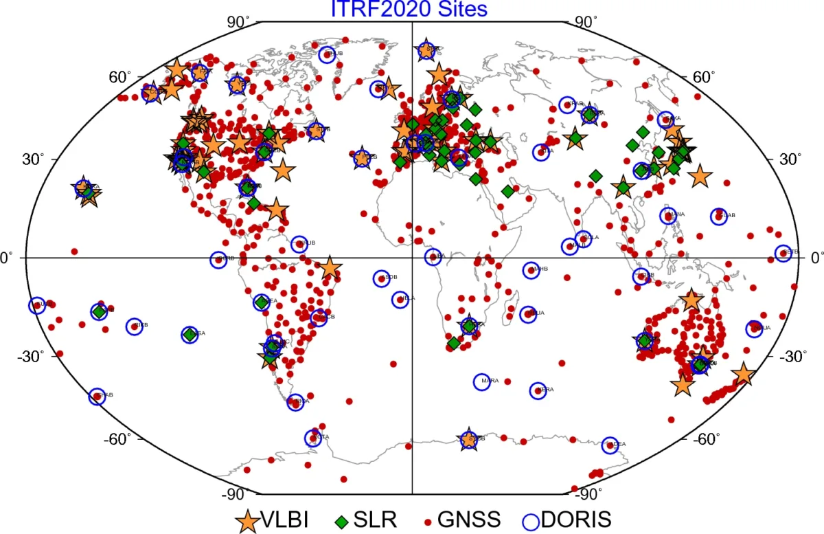
Reference frames are periodically updated to maintain (and improve!) their accuracy. International Terrestrial Reference Frame ITRF2020 was released in 2023, following the previous ITRF2014, ITRF2008, and ITRF2005.
In 1884, a number of countries agreed on the location of the Prime Meridian (0° longitude) running through the Royal Observatory in Greenwich, England. But if all the Earth’s plates are moving, and local processes could affect the Royal Observatory, how do we maintain longitude in a globally meaningful and precise way over time? Similarly, the equator (0° latitude) was defined as the midway line between the North and South geographic poles in 1900-1905. The geographic poles also move slightly over time, so how do we keep the equator from moving?
This is why we need so many different kinds of measurements from all around the world. With an absolute reference frame, the axes of the coordinate system can be fixed as precisely as possible without varying regional changes causing the whole thing to slip around.
This also helps nations (like the United States) that maintain their own map coordinate systems to align them within a shared global system, making them more accurate and ensuring agreement with each other.
Elevation
It’s not just latitude and longitude coordinates that require a reference system — the same is true for elevation. Calculating elevation, generally expressed as a height above sea level, is more complicated than it seems.
One reason for this is that the Earth is not perfectly spherical, it’s an ellipsoid. The circumference of the Earth around the equator is a little bit longer than the circumference of the Earth from pole to pole. Because GPS/GNSS satellites simply orbit the center of the Earth’s mass, failure to account for this shape would make GPS-calculated elevations inaccurate.
Another reason is that Earth’s gravitational field is not uniform around the globe because of variations in the solid Earth. This means that sea level is not even a perfectly smooth ellipsoid. We represent this reality with a lumpy shape called the geoid.
To accurately calculate elevation, then, we need to use both a reference ellipsoid and a reference geoid — an International Height Reference Frame. To understand how this works, check out our tutorials: