


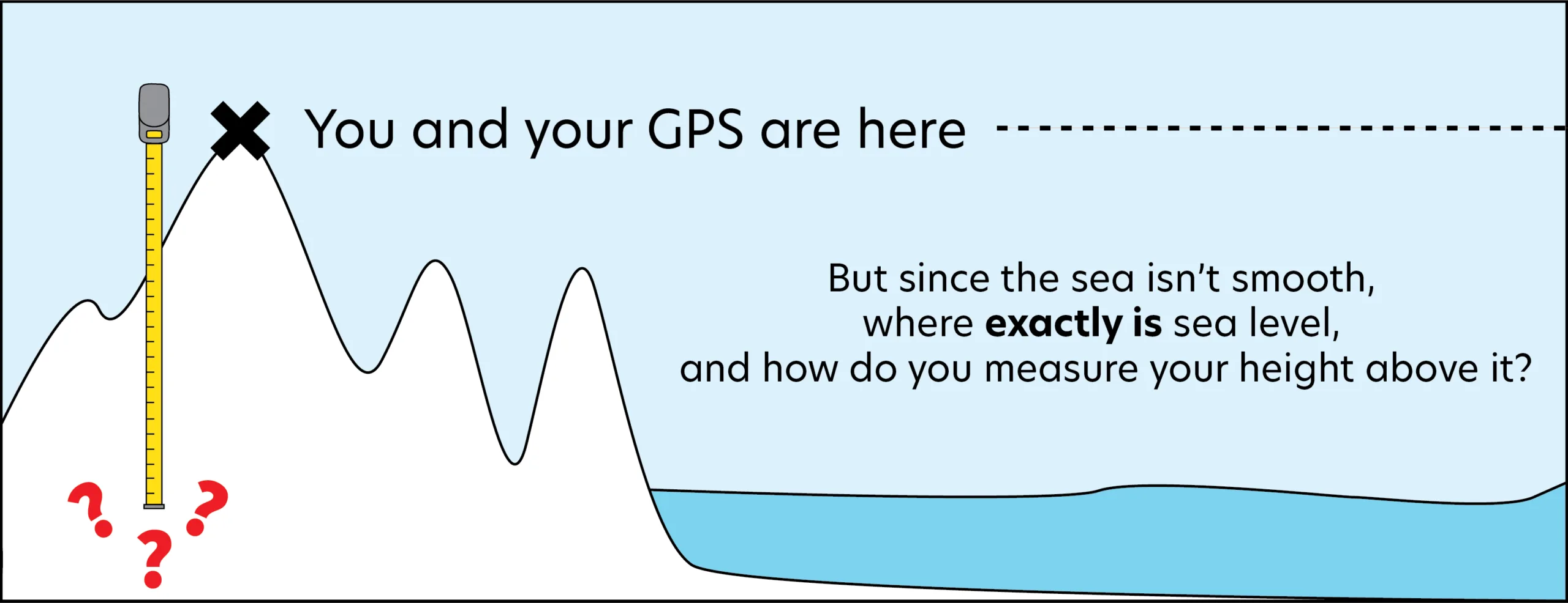
If you’ve heard of the reference ellipsoid, you are probably aware that GPS receivers use this smoothed model of Earth’s shape to estimate elevations above sea level. But there are limitations to this; Earth is not a perfect ellipsoid, and sea level is not actually the same everywhere on Earth. So, if you are standing at the top of a mountain that is hundreds of miles from the nearest coastline and want to use a GPS to find your precise elevation, how do you know what measurement of “sea level” your GPS elevation is relative to? The geoid helps us answer this question.
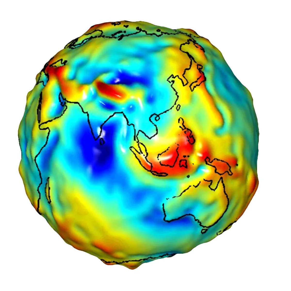
In order to understand the geoid, we first need to understand why sea level varies across Earth. Tides, winds, and currents certainly contribute to these variations, but even after accounting for the oceanographic and atmospheric effects, the actual surface of the ocean is still bumpy. It turns out that those bumps are a reflection of the mass distribution between Earth’s surface and the center of the planet.
Why does mass distribution matter?
All objects have mass. Gravity is an attraction between two masses that causes them to accelerate towards one another. Without gravity, if you held a pencil in the air and let go, it would just float (like it does for astronauts at the International Space Station). With gravity, if you hold the pencil and then let go, it falls to the ground. More specifically, the pencil accelerates towards Earth and Earth accelerates towards the pencil. Now you might think, “I have never seen the ground move towards my pencil when I drop it!” That’s because Earth is so much more massive than everything on it, so we can’t detect the planet moving towards things when we drop them.
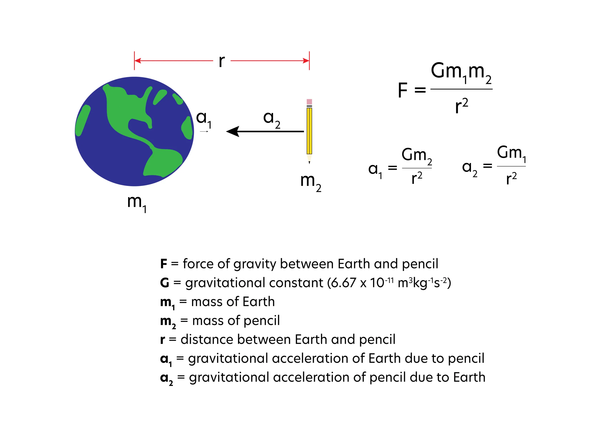
Below is a cartoon that depicts a pencil accelerating towards the center of Earth (big black arrow) and Earth accelerating towards the pencil (tiny black arrow). The equation for gravitational force, F, can be used to calculate the gravitational attraction between Earth (mass, m1 = 5.97 x 1024 kg) and the pencil (mass, m2 = 0.001 kg). Try the calculation by assuming that the distance from the surface of Earth to its center is approximately 6,360,000 meters, and that your hand is roughly 1 meter above that surface. Then, calculate the gravitational acceleration of Earth towards the pencil and the pencil towards Earth.
Which acceleration is bigger? (Expand the dropdown to see the answer).
Known Values
G = 6.67 x 10⁻¹¹ m3 kg-1 s-2
m1 = 5.97 x 1024 kg
m2 = 0.001 kg
r = 6360001 m
Unknown Values
F = ?
a1 = ?
a2 = ?
To calculate the force of gravitation between the Earth and the pencil we use the equation for F.
F=Gm1m2/r2
F=((6.67 * 10-11 m3 kg-1 s-2)*(5.97 * 1024 kg)*(0.001 kg)) / (6360001 m)2
F=0.009844325 kgm/s2
To calculate the acceleration of the Earth towards the pencil we use the equation for a1.
a1=Gm2/r2
a1=(6.67 * 10-11 m3 kg-1 s-2)*(0.001 kg) / (6360001 m)2
a1=1.65 * 10-27 m/s2
To calculate the acceleration of the pencil towards the Earth we use the equation for a2.
a2=Gm1/r2
a2=(6.67 * 10-11 m3 kg-1 s-2)*(5.97 * 1024 kg) / (6360001 m)2
a2=9.84 m/s2
Notice how tiny the acceleration of the Earth is compared to the acceleration of the pencil. This is why we can’t tell that the Earth is moving towards the pencil. Also notice how close the acceleration of the pencil is to the accepted average value for the acceleration of gravity on Earth’s surface (9.81 m/s2)!
We’ve just learned that a pencil and Earth accelerate towards each other differently because each has a different mass. Let’s now expand this concept of gravitational attraction and acceleration and apply it to answering the question of why the true shape of sea level is complex.
The Geoid Model
The ocean floor is far from being flat and featureless. In fact, underwater volcanoes, mountain chains, fractures, faults, trenches, and other features are found under our oceans and cause mass to vary. Furthermore, scientists have mapped rocks with different densities beneath the seafloor. Because physics dictates that water has to come into equilibrium with the local gravitational attraction, the surface of the ocean molds itself into bumps and troughs to reflect these differing gravitational attractions. This surface is known as an equipotential surface, where the potential energy is the same everywhere. For example, a large volcano sitting on the seafloor tends to pull ocean water towards it, making the surface of the ocean pile up above it. For some large, dense volcanoes, the surface of the ocean is piled up to a height of a few meters above it! In contrast, an oceanic trench does not exert as much pull as do the surrounding regions, so water moves away and creates a small trough in the ocean’s surface above the trench.
This bumpy ocean surface that is free of time-varying effects like tides and currents is called the geoid, or reference geoid. The geoid exists in continental areas too; imagine taking a smooth ellipsoid but giving it the same mass distribution as the real, bumpy Earth. The undulatory surface of the reference geoid can be estimated as the level that would be taken by the surface of the sea over this smooth ellipsoid with varying density, measured relative to the reference ellipsoid. Just like the ocean floor, land surfaces have mountains, valleys, and other topographic features that affect the local gravity field and thus, the reference geoid. We need to take the mass variations of these features into account to estimate what “sea level” would be at inland areas, because the actual sea level changes with underwater volcanoes and other hidden features. The complicated nature of the reference geoid explains why a simplified smooth reference ellipsoid is instead used in GPS receivers!
The image below is a visualization of the reference geoid. There are, in fact, different reference geoids for different areas of the world, depending upon which specific reference level is desired. The global version shown here is the WGS-84/EGM96 reference geoid. The “WGS-84” in its name indicates the specific reference ellipsoid used, and “EGM96” indicates the specific gravity model used to produce the geoid. WGS-84/EGM96 is currently the best model we have for approximating the true surface of the ocean and where this equipotential surface would extend into the continents.
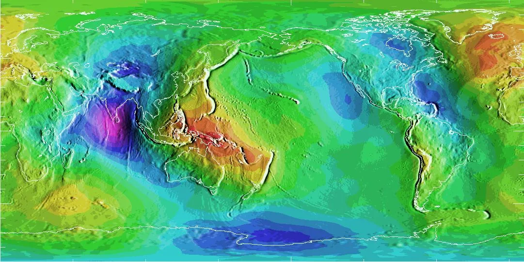
You may wonder if GPS readings you have used in the past for things like navigation are significantly off because the geoid wasn’t taken into account. In the figure above, the purple and blue spots are depressions in the “sea level”, while the red areas are high points. In the areas with the most extreme deviations from the reference ellipsoid, the geoid is still only about a football field (~100 meters) above or below the reference ellipsoid; the vast majority of variations are much smaller. For most everyday applications, like navigation with a phone or fitness tracking with a GPS watch, the elevations relative to the ellipsoid are usually close enough to be useful without accounting for the geoid. However, one hundred meters, or sometimes even one meter, is a significant difference for mapping and scientific applications and the geoid is required to produce useful results. For example, engineers designing flood mitigation systems must use precise elevations to properly grade land surfaces, and pilots use navigation systems that include geoid heights to avoid flying into terrain.
Putting it All Together
Think back to our original scenario of finding the precise elevation of a mountain with a GPS. In order to precisely obtain and compare elevations, we need to use the geoid to take into account those variations in sea level across Earth’s surface. Topographic surface elevations used in mapping, also known as orthometric heights, are usually reported as the distance in meters or feet above or below sea level–which means the distance above or below the reference geoid. But, our GPS receiver measures the height of the receiver above the smooth reference ellipsoid. So, how do we calculate the GPS receiver’s height above the reference geoid?
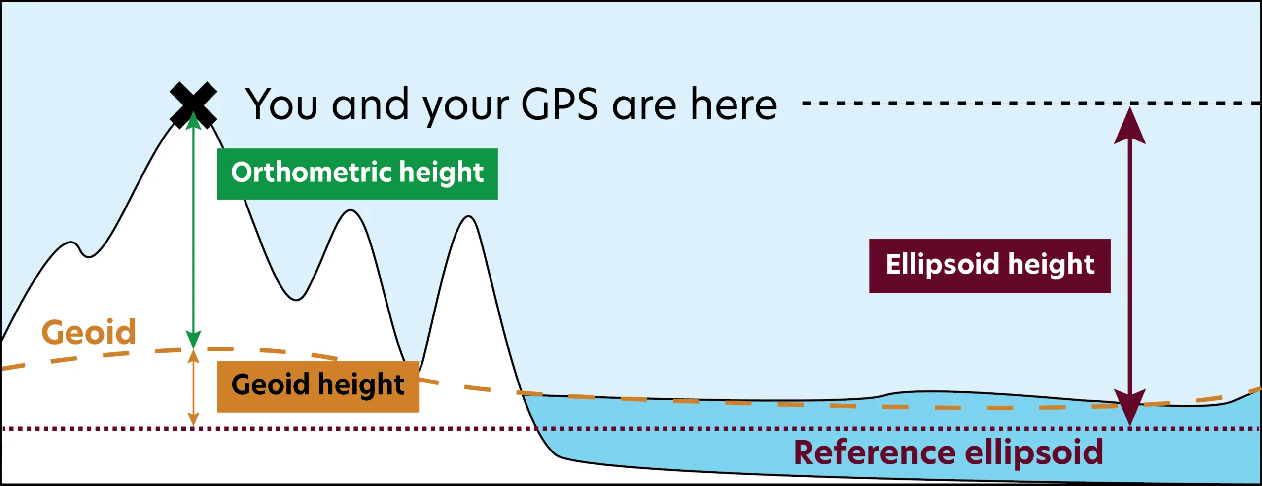
We know the elevation of the GPS receiver above the reference ellipsoid (this height is often called the ellipsoid height). And, from a model like the WGS-84/EGM96 reference geoid we can find the height of the reference geoid at our latitude and longitude above the reference ellipsoid–you can find this value using the Geoid Height Calculator. So, the orthometric height of the receiver above sea level is simply the difference between these two values:
Orthometric Height = Ellipsoid Height – Geoid Height
Example
- A student took 15 readings of her position with a GPS receiver and then calculated the average of these readings, which she wrote down.
- Latitude = 40 degrees 2.08 minutes North
- Longitude = 104 degrees 14.25 minutes West
- Elevation = 1602 meters (ellipsoidal height)
- Next, the student visited the Geoid Height Calculator. She entered her latitude and longitude where indicated and got a geoid height of -15.9 meters.
- Geoid Height = -15.9 meters
- Finally, the student used these numbers to calculate her orthometric height.
- Orthometric Height = Ellipsoidal Height – Geoid Height
- Orthometric Height = 1602 meters – (-15.9 meters)
- Orthometric Height = 1617.9 meters
In summary, sea level varies across Earth’s surface due to changes in the underlying mass. To accurately find elevation above sea level, one must find the difference between the height above the reference ellipsoid and the height of the reference geoid at that point on Earth.