


If you have explored the GPS Velocity Viewer or examined other maps of GPS/GNSS motion, you may have noticed descriptions of reference frames–so what are they and why do we use them?
Earth’s surface is not stationary. Different places on Earth move in different directions and at different speeds. The speeds are very slow–usually slower than your fingernails grow–but these motions make mountains and cause earthquakes. Over millions of years, continents move thousands of miles and push up mountain ranges like the Himalayas. GPS velocity vectors show precisely how Earth’s surface is moving today. But you might ask, moving as compared to what? Since every location on Earth is moving, we can only compare how fast one place is moving compared to another place.
Scientists use certain regions as standard places to compare to, like points of view. The motions of GPS stations relative to each of these locations are known as reference frames (see timestamp 0:48 of Measuring Plate Tectonics with GPS video). If you are examining velocities in the reference frame of North America, it would be equivalent to standing in eastern North America and seeing how other places move from your point of view. You might wonder how the Pacific plate is moving past North America, and use North America as the reference frame. However, if you are interested in how the Pacific plate is moving past a location that is not in North America, you would select a different reference frame that includes your location of interest.
The GPS Velocity Viewer allows users to view GPS velocities from around the world in different reference frames, including the global IGS08, and many regional reference frames. Each station’s velocity vector is depicted as an arrow, with the direction and rate of movement indicated by the direction and length of the arrow. For example, the figures below from the Station Velocity Viewer show velocities of stations in South America for two different reference frames.
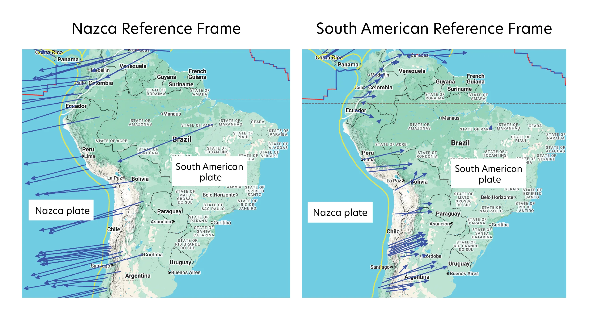
As can be seen from the figures, velocities vary significantly depending on the reference frame used. Because the Nazca and South American plates are slowly converging, the velocities all converge towards a “stable” portion of the reference frame’s plate. The location of this stable region in the South American reference frame is illustrated well by the station north of the South American Plate label; this station’s velocity is rapid in the Nazca reference frame, but nearly zero in the South American reference frame.
A variety of data can be visualized in the GPS Velocity Viewer. Network of the Americas (NOTA) GPS derived data products are available in two reference frames: the North American plate (NAM14) and a global reference frame (IGS14). NAM14 assumes that the interior, eastern part of North America is stable and rigid; all deformation at the plate boundaries (particularly apparent that the western boundary) is shown in relation to the stable part of the plate. IGS14 is a “no net rotation” (NNR) reference frame. NNR reference frames show the motion of each plate with respect to the weighted average of all of the world’s plate velocities. IGS14 is sometimes referred to as absolute plate motion, since it appears to approximately represent the motions of the surface plates with respect to Earth’s deep interior. It closely resembles the apparent motion of the world’s plates with respect to hot spot volcanoes and is based on the International Terrestrial Reference Frame (ITRF).
Global Earthquake Model Strain Rate Map Project (GEM GSRM) reference frames can also be visualized in the GPS Velocity Viewer; the project provides several reference frames (including a NNR reference frame) comprised of thousands of velocity vectors from around the globe.