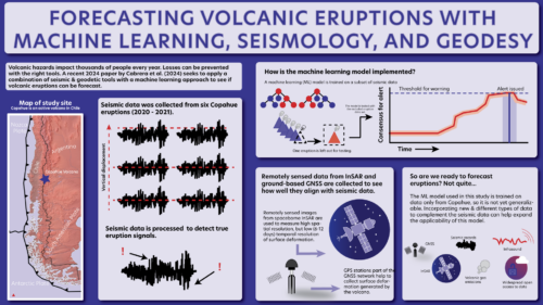
Pairing machine learning with GNSS and InSAR could help forecast eruptions
A new machine learning methodology utilizes seismic data to see if a volcanic eruption can be forecasted.
Here in the News & Features section, you can find important announcements or learn more about our work and the science we support.
A new machine learning methodology utilizes seismic data to see if a volcanic eruption can be forecasted.
Different forces are tearing the western U.S. apart. Which ones are most important?
In Western Antarctica, the Pine Island Glacier ice shelf cracks and calves. One of these rifting events was observed via seismic sensors, demonstrating that while the tear was slower than expected, it’s still the fastest through-cutting fracture in a floating ice shelf ever recorded.
As the world warms, glaciers retreat, leaving behind over-steepened slopes that are prone to landslides. In places like coastal Alaska, landslides that slip into the ocean can spell disaster.
Wind-driven ocean waves beat on Earth’s seafloor, creating a continuous signal for which seismic stations around the world listen—a signal that is increasing.
Though Chile is known for several major earthquakes, the Atacama seismic gap features slow movement that scientists seek to unravel.
Changes in trace amounts of the element thorium in two Colorado catchments appear to be explained by subsurface fracturing. The cause of fracturing might be attributable to distant earthquakes.
On February 6th, 2023, Türkiye and Syria experienced the devastating effects of two large (magnitude 7.8 and 7.5) earthquakes, which triggered more than 200 aftershocks. A recent study led by first author, Gesa Maria Petersen, maps two fault zones using data produced from these earthquakes, uncovering never before mapped fault sections and ground motion along these faults.