

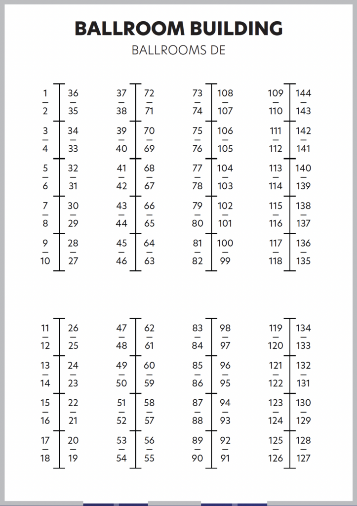
Registration is in the Ballroom Building

Registration closed on March 19.
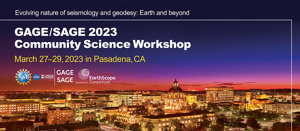
This workshop focuses on cutting edge geophysical results of processes in the solid earth, cryosphere, oceans, atmosphere, and even other planets. It highlights synergies between the geodetic and seismic research communities in time, space, and methods for approaching datasets and changes in the Earth System. It provides an opportunity to learn about cutting edge research, engage with other members of the community, and expand technical skills.
The Workshop is sponsored by the the National Science Foundation (NSF), National Aeronautics and Space Administration (NASA), and US Geological Survey (USGS). The Geodetic Facility for the Advancement of Geoscience (GAGE) and the Seismological Facility for the Advancement of Geoscience (SAGE) are run by EarthScope Consortium, through cooperative agreements with NSF. EarthScope Consortium was formed through a merger of IRIS and UNAVCO.
Format
The workshop will be held in-person with no virtual component.
All meeting attendees will be required to adhere to the EarthScope Code of Conduct.
Poster size maximum: 4’x4′ (114×114 cm)
Workshop Goals
- Facilitate geodetic and seismic scientific research by sharing results and planning future endeavors, and
- Foster community among geodetic and seismic researchers, faculty, students, and facility staff,
- Provide a venue for professional development in scientific and technical careers.
Workshop Leadership
Science Planning Committee:
- Caroline Beghein, University of California Los Angeles
- Kristel Chanard, Université de Paris
- Eric Lindsey, University of New Mexico
- Zhongwen Zhan, California Institute of Technology
EarthScope Planning Contacts:
- Beth Pratt-Sitaula, EarthScope Consortium
- Justin Sweet, EarthScope Consortium
Have questions? Please contact community![]() earthscope.org for more information.
earthscope.org for more information.
COVID Protocols
We will be following the local health orders for Pasadena, California. At the time of writing (March 24, 2023) the City of Pasadena had recently rescinded it’s state of emergency regarding COVID and recommends that people follow CDC guidelines related to vaccination and State of California guidance related to masking.
Although the City of Pasadena is no longer strongly recommending that individuals wear face masks while indoor in all workplaces and public settings, the GAGE/SAGE Workshop will still have masks and COVID test kits available at registration for anyone who needs them.
As part of the registration process, participants committed to not attending workshop events if they test positive or develop symptoms during or within 5 days of the start of the workshop, or as otherwise recommended by local health orders.
| Important Dates |
| Student/Postdoc Travel Scholarship Application Deadline Special Interest Group Proposal Deadline January 24 |
| Early Bird Registration (poster presenters must register during the early bird period) January 24 – February 24 (ends 11:59 ET) |
| Discount Hotel Booking Deadline Exhibitor Reservation Deadline February 24 |
| Poster Abstract Submission Deadline (only available to people who registered during the early bird period) Registration Refund Request Deadline (COVID exception) March 3 |
| Registration Closes March 19 (ends 11:59 ET) |
| Short Courses Sunday March 26 |
| Workshop Monday March 27 morning – Wednesday March 29 noon |
Registration is in the Ballroom Building
| Registration fees |
| Early Bird Registration (January 24 – February 24) |
| $200 student/postdoc |
| $400 regular |
| Regular Registration (February 25 – March 19) |
| $250 student/postdoc |
| $500 regular |
| Participants currently at institutions in low and low-middle income countries may request a fee waiver. We use the economic definitions given by the World Bank. Please contact community |
Refunds: 100% refund available until March 3. No refunds issued after March 3 (COVID exception). Contact community![]() earthscope.org for a refund request.
earthscope.org for a refund request.
Plenary Sessions
Earth and Planetary Structure – Monday morning
This session brings together seismological and geodetic studies of the interior of the Earth and other planets that contribute to our understanding of planetary structure, formation, and evolution. It will highlight studies using new datasets, modeling approaches, or observational techniques to explore the structure of a planet and to help relate surface processes to the interior. A short list of examples includes geodetic inferences on viscosity or density, plate deformation, or seismological studies of wave velocities, attenuation, anisotropy and core or mantle dynamics.
Chairs: Ebru Bozdag (Colorado School of Mines), Corné Kreemer (University of Nevada Reno)
- Linking Surface Deformation with Mantle Dynamics from Numerical Modeling with Data Assimilation – Lijun Liu (University of Illinois)
- Weak Base of the Upper Mantle Revealed by Postseismic Deformation Following a Deep (~560 km) Earthquake – Sunny Park (University of Chicago)
- Probing Lowermost Mantle Dynamics with Observations of Seismic Anisotropy – Jonathan Wolf (Yale University)
- InSight on Mars, 2018-2022: What a Single Station on Mars was able to Reveal About the Interior from Near-surface to the Core – Mark Panning (JPL)
Hazards, Transients, and Society – Monday afternoon
Modern seismic and geodetic techniques (and their combinations) have given us the ability to sense transient crustal processes in unprecedented detail. This session focuses on new measurement techniques and new observations of Earth hazards (earthquakes, volcanoes, landslides, etc.) and other transient sources, and on the insight these data can provide into the physical processes driving such events. A crucial component of hazard mitigation involves effective and timely public outreach and engagement; this session also serves to highlight these efforts. We invite discussion on how SAGE & GAGE can help us better prepare (scientifically and societally) for future occurrences.
Chairs: Roby Douilly (University of California Riverside), Dara Goldberg (USGS)
- The Value and Challenges of High Spatial Resolution Satellite Observations for Volcano Science and Hazard Mitigation – Matthew Pritchard (Cornell University)
- Towards Volcanic Hazards Assessment Using Transient Detection in the Natron Rift, Tanzania – D. Sarah Stamps (Virginia Tech)
- Earthquake Early Warning Along the US West Coast: Improving Detection and Characterization of Offshore Events with Limited Data – Amy Williamson (University of California Berkeley)
- Satellite Sensing of Precursory Motion for Landslide Inundation Forecasting – Yuankun Xu (University of California Berkeley)
Evolving Landscape and Climate – Tuesday morning
Advances in seismo-geodetic observations provide an unprecedented opportunity to study environmental processes beyond the solid Earth. This session explores the potential of these observations to quantitatively monitor various variables relevant to further our understanding of the evolving landscape and climate. Examples of variables include, but are not restricted to, terrestrial water storage, ice sheet and glacier mass, sediment transport, tropospheric water vapor and sea level.
Chairs: Marine Denolle (University of Washington), Chris Harig (University of Arizona)
- DAS in the Cryosphere – Dominik Graeff (University of Washington)
- Groundwater Monitoring Using GNSS – Justine Overacker (University of Nevada Reno)
- Seismo-geomorphology – Danica Roth (Colorado School of Mines)
- Open Science with IcePyx – Jessica Scheick (University of New Hampshire)
Seafloor and Marine Geophysics – Tuesday afternoon
This session highlights new technologies, sensing capabilities, and sciences in areas beyond land, including but not limited to seafloor geodesy and seismology, submarine fiber-optic sensing, and ocean wave monitoring. Offshore data currently occupy a small fraction of the SAGE/GAGE facility but are bound to grow rapidly and contribute insights to key geophysics questions and beyond.
Chairs: Noel Bartlow (University of Kansas), Ƶack Spica (University of Michigan)
- Imaging the Cascadia Subduction Zone with Marine Active Source Seismic Data – Shoushou Han (University of Texas)
- Geodesy on the Seafloor – Mark Zumberge (UCSD/SIO)
- Probing the Solid Earth and the Hydrosphere with Ocean-Bottom Distributed Acoustic Sensing – Loïc Viens (LANL)
- Marine Geophysical Studies of a Vapor-Driven Hydrothermal Field on the Floor of Yellowstone Lake – Robert A Sohn (WHOI)
New Opportunities and Future Directions – Wednesday morning
This forward-looking session explores the frontiers of geophysics in areas such as instrument design and development, data analyses, and new/upcoming collaborations that are expanding the reach of geophysics. We highlight new technologies and how they are helping to advance geophysics on Earth as well as on other planets. We also look at how innovative approaches to data analysis allow us to learn more from new and existing datasets and also explore the evolving opportunities for interdisciplinary geodesy and seismology.
Chairs: Peter James (Baylor University), Mark Panning (JPL)
- The Future of Seismology Across the Solar System – Dani Della Giustina (University of Arizona)
- Future Lunar Geophysical Mission Opportunities including the Lunar Geophysical Network – Heidi Fuqua Haviland (NASA Marshall Space Flight Center)
- Geodesy Transforming Our Understanding of Planetary Interior – Anton Ermakov (University of California Berkeley)
- Electromagnetic Investigations of the Interiors of Solid Worlds – Robert Grimm (Southwest Research Institute)
- Odd-numbered posters on Monday March 27 (4:00-5:45 pm)
- Even-numbered posters on Tuesday March 28 (4:15-6:00 pm)
- Poster size maximum: 4’x4′ (114×114 cm)
- Posters are grouped by author-selected alignment to plenary themes
- 1-50 – Earth and Planetary Structure
- 51-98 – Hazards, Transients, and Society
- 99-116 – Evolving Landscape and Climate
- 117-124 – Seafloor and Marine Geophysics
- 125-132 – New Opportunities and Future Directions
- 133-138 – Facility Support, Education, Broader Impacts
Short Courses
Free half- and whole-day short courses will be offered Sunday March 26, 2023—the day before the main workshop starts.
You can register for short courses during the regular workshop registration process. Short courses are concurrent. You can only sign up for one. Space is limited. PLEASE ONLY SIGN UP if you actually plan to attend. If you decide at a later date you would like to register for a short course, contact community![]() earthscope.org.
earthscope.org.
For students/postdocs who receive travel scholarships, you will be eligible for an additional $150 support stipend if you attend a short course and need an additional night of hotel.
Conference Center Rm 101
All-day short course: 8:00 am-5:30 pm (lunch break 12-1:30 pm)
Presenters: Mike Floyd and Tom Herring (MIT)
GAMIT/GLOBK In A Day introduces GNSS data processing and analysis using GAMIT/GLOBK (http://geoweb.mit.edu/gg/). The course is designed to acquaint participants with the most common uses of GAMIT/GLOBK: generating geodetic time series and velocities from GNSS data for tectonic geophysics studies. This course is intended to be a primer and prerequisite for participation in our longer, advanced Short Courses, hosted by GAGE periodically.
Audience: The course is designed for beginners and novices who wish to get started with the software and get assistance developing their experiments, as well as those seeking to refresh their knowledge of the software from the basics or otherwise interact with the software developers and maintainers.
Computer needs: Participants are welcome to attend for informational purposes, such as trying to understand if the GAMIT/GLOBK software will be useful for a given project. All other participants require a laptop and must have acquired a license to run the software before attending the course. We also encourage participants to read through the GAMIT/GLOBK “Quick Start Guide” (http://geoweb.mit.edu/gg/docs/GG_Quick_Start_Guide.pdf), as well as install the software and at least work through the test package before attending where possible, although we will also cover this during the course.
Ideally each participant will come with a project and/or data in mind, with which to practice throughout the day.
Course goals
Participants will:
- Learn various uses of GAMIT/GLOBK for GNSS processing, including standard daily session processing using GAMIT and GLOBK, and high-rate kinematic processing using track
- Have verified and tested installation, and begun to build their own experiment, in preparation for independent use after the course
- Gain familiarity with common issues, where they arise, to find solutions and progress independently
For course content questions contact Mike Floyd (mfloyd![]() mit.edu)
mit.edu)
For Science Workshop logistical questions contact community![]() earthscope.org
earthscope.org
Conference Center Rm 102
This course filled as of February 22 – 11 am ET. No further registrations can be taken.
All-day short course: 8:00 am-5:30 pm (lunch break 12-1:30 pm)
Presenters: Eric Lindsey (University of New Mexico), Ann Jingyi Chen (University of Texas Austin)
The expansion of cloud-based routine processing efforts accompanying the Sentinel-1 mission, and in anticipation of the forthcoming NISAR mission, have dramatically expanded the volume of processed InSAR data in the public domain, providing access to user-friendly InSAR data products. In this full-day short course, we will focus on how to analyze and interpret InSAR data products acquired from modern radar satellites.
Audience: graduate students and researchers interested in learning more about InSAR.
Please plan to bring a laptop computer to the course. No preparatory other work will be needed.
Course goals
Participants will learn:
- InSAR background theory and processing methods
- Common data errors and issues
- The range of SAR satellite missions and data repositories
- Time series analysis, data interpretation, and ingesting data into modeling efforts
For course content questions contact Eric Lindsey (eol![]() unm.edu)
unm.edu)
For Science Workshop logistical questions contact community![]() earthscope.org
earthscope.org
Conference Center Rm 103
All-day short course: 8:00 am-5:30 pm (lunch break 12-1:30 pm)
Presenters: Wang-Ping Chen (University of Illinois & China University of Geosciences Wuhan), Chunquan Yu (SUSTech), Jiaqi Li (UCLA), Tianze Liu (UCSD), Sifang Chen (University of Chicago), Qing Chen (China University of Geosciences Wuhan)
In comparison with conventional approaches using manmade sources, Virtual Deep Seismic Sounding (VDSS) offers a simple, robust, and low-cost alternative to investigate seismic properties of the crust and the upper mantle. The key in VDSS is that it utilizes strong, deep-penetrating signals from the conversion of shear- to compression-wave near each seismic station as a virtual source of seismic reflection. So, each recording of an earthquake at any seismic station carries its own, free seismic source for probing the lithosphere near that station.
Recent advances in VDSS, including the use of both post-critical and pre-critical reflections, and auxiliary seismic phases, not only determines bulk crustal properties such as compression- and shear-wave speeds, and thickness, but also constrain the speed and anisotropy of the compression-wave in the uppermost mantle (in lieu of the phase Pn). Furthermore, the method has the capability of investigating additional interfaces within the lithospheric mantle and the crust. The robust, simple nature of VDSS enables individual scientists or small research groups to make significant progress by using the voluminous, public domain data from natural earthquakes.
In addition to applications of VDSS to various regions around the globe with distinct tectonic settings, this technique has been applied to Martian data, constraining properties of the top 10 km of crust near the NASA InSight mission landing site.
Audience: graduate students and researchers interested in expanding their seismic research methods
Requirements: Only a basic knowledge of seismology and digital signal processing is needed but the course assumes functional proficiency of the Linux/Unix OS. Each participant must have their own Linux/Unix-enabled laptop computer to perform hands-on exercises throughout the day
Course goals
Participants will:
- Be able to apply VDSS to their own research applications
- Make their own long seismic profiles using data from a single, deep-focus earthquake
- See how to use numerous shallow earthquakes to facilitate the investigation of a wide range of seismic properties of the crust and the lithospheric mantle, including but not limited to the construction of 3-D crustal thickness maps
For course content questions contact Wang-Ping Chen (wpchen![]() illinois.edu).
illinois.edu).
For Science Workshop logistical questions contact community![]() earthscope.org
earthscope.org
Conference Center Rm 104
Half-day short course: 1:30-5:30 pm
Presenters: Ellen Yu, Gabrielle Tepp, Ettore Biondi, Aparna Bhaskaran, Shang-Lin Chen (Caltech)
Are you working on or interested in Southern California seismicity? Would you like to know the ins and outs of Southern California Seismic Network (SCSN) data? Do you want to optimize your data access? Then this short course is for you! In this half-day course, we aim to better prepare researchers for using data from the SCSN.
The course will cover two main topics: available data products for Southern California seismicity and how to access those products. We will start by detailing SCSN data products, including the earthquake catalog, waveform data, moment tensors, DAS, and more. Participants will learn how the data products are generated and information about their metadata, parameters, and limitations. In the second section, we will cover methods for accessing data products through the Southern California Earthquake Data Center (SCEDC): web services, cloud access via Amazon Web Services, and directly in code via FDSN tools and STP. These two informational sections will be followed by open time for questions, discussion, and exercises. Feel free to bring your own project or try our tutorials.
Audience: This short course is aimed towards anyone interested in working with Southern California seismic and earthquake data. We welcome new users who want to learn more about what we offer, as well as seasoned researchers who are looking for a more thorough understanding of SCSN/SCEDC products and services.
Please plan to bring a laptop computer to the course. While no preparatory work is required, we highly recommend prior installation of the programming tools (e.g., Python, Matlab) that you are interested in working with.
Course goals
Participants will:
- Learn available SCSN data products
- Understand how the data products are generated and their parameters and limitations
- Be able to access SCSN data through SCEDC tools and services, such as the website, FDSN tools, and Amazon Web Services
For course content questions contact Gabrielle Tepp (gtepp![]() caltech.edu) or Ellen Yu (eyu
caltech.edu) or Ellen Yu (eyu![]() caltech.edu).
caltech.edu).
For Science Workshop logistical questions contact community![]() earthscope.org
earthscope.org
Travel Support Scholarships
Undergraduates, graduate students, and postdocs from U.S. domestic colleges and universities are all eligible to apply for travel support scholarships. The application period is now closed. All recipients have been notified. Selected applicants will receive a travel stipend of up to $1000 to offset attendance costs (e.g. transportation, hotel, registration). Recipients are required to pay the workshop registration fee. List of Travel Support Scholarship Recipients
Venue
The Workshop will be held at the Pasadena Convention Center in Pasadena, California.
Registration is in the Ballroom Building – Venue Map
300 E. Green Street
Pasadena, CA 91101
Local Information
- Restaurants & Dining in Pasadena (opens in new tab)
- Food on Foot in Pasadena (opens in new tab)
- Things to do Around Pasadena (opens in new tab)
Airports
The Pasadena, California is served by three area airports.
- Burbank Hollywood Airport (BUR) – 18 miles
- BUR ground transportation information (opens in new tag)
- Los Angeles International Airport (LAX) – 29 miles
- LAX ground transportation information (opens in new tab)
- Ontario International Airport (ONT) – 36 miles
- ONT ground transportation information (opens in new tab)
Parking
Pasadena Convention Center Parking & Directions (opens in new tab)
Hotels
Pasadena: Places to Stay (opens in new tab)
A variety of local hotels offered discounted courtesy blocks during the registration Early Bird period but that option is now closed.
| First Name | Last Name | Institution |
|---|---|---|
| Niloufar | Abolfathian | JPL-Caltech |
| Mateo | Acosta | California Institute of Technology |
| Kasey | Aderhold | EarthScope Consortium |
| Victor | Afigbo | University of Idaho |
| Kayode | Agboola | The University of Alabama, Tuscaloosa |
| Mir | Alam | Bowling Green State Univeristy |
| Richard | Allen | University of California Berkeley |
| Kent | Anderson | EarthScope Consortium |
| Solene L | Antoine | Jet Propulsion Laboratory |
| Tamara | Aránguiz | University of Washington |
| Donald Francis | Argus | Jet Propulsion Laborartory |
| Aris G. | Aspiotes | USGS |
| Rick | Aster | Colorado State University |
| Carmen | Atkins | Virginia Tech |
| Jimmy | Atterholt | California Institute of Technology |
| Dan | Auerbach | UCSD-Scripps Institution of Oceanography |
| Ken | Austin | EarthScope Consortium |
| Brad | Avenson | Silicon Audio |
| Forest | Banks | Battelle Memorial Institute |
| Andy | Barbour | USGS |
| Noel M | Bartlow | University of Kansas |
| Gerald | Bawden | NASA Headquarters |
| LUIS IVAN | BAZAN FLORES | The University of Memphis |
| Bruce | Beaudoin | EarthScope Primary Instrument Center |
| David | Bekaert | JPL-Caltech |
| Becks | Bendick | EarthScope Consortium |
| Aubrey | Bennett | University of Arizona |
| Rick | Bennett | National Geodetic Survey |
| Maggie | Benoit | National Science Foundation |
| Henry | Berglund | EarthScope Consortium |
| Susan | Bilek | New Mexico Tech |
| Ettore | Biondi | California Institute of Technology |
| Michael | Blanpied | USGS Earthquake Hazards Program |
| Freddy | Blume | EarthScope Consortium |
| Omer | Bodur | The University of Texas at Dallas |
| David | Bonck | National Geodetic Survey |
| Adrian | Borsa | University of California San Diego |
| Ebru | Bozdag | Colorado School of Mines |
| Emily | Brodsky | University of California Santa Cruz |
| Mike | Brudzinski | Miami University |
| Brennan | Brunsvik | University of California Santa Barbara |
| Roland | Bürgmann | University of California Berkeley |
| Bob | Busby | EarthScope Consortium |
| D.J. | Bustos | EarthScope Primary Instrument Center |
| Kristel | Chanard | IPGP |
| Donna | Charlevoix | EarthScope Consortium |
| Cam | Chavez Reed | The University of New Mexico |
| Ann | Chen | The University of Texas at Austin |
| Kai | Chen | Brown University |
| Qing | Chen | China University of Geosciences Wuhan |
| Sifang | Chen | The University of Chicago |
| Wang-Ping | Chen | China University of Geosciences Wuhan University of Illinois Urbana-Champaign |
| Yu | Chen | The University of Texas at Dallas |
| Zhi-ang | Chen | Arizona State University |
| Yifang | Cheng | University of California Berkeley |
| Jeng Hann | Chong | University of New Mexico |
| Gail | Christeson | National Science Foundation |
| Lindsay | Chuang | Georgia Institute of Technology |
| Rob | Clayton | California Institute of Technology |
| John | Collins | Woods Hole Oceanographic Institution |
| Norma A. | Contreras | University of California Riverside |
| Shyane | Cornell | California State University Northridge |
| Gale J. | Cox | EarthScope Consortium |
| Chris | Crosby | EarthScope Consortium |
| Brendan | Crowell | University of Washington |
| Andrew | Dalby | Nanometrics |
| Jensen | DeGrande | University of Washington |
| Kimber | DeGrandpre | National Geodetic Survey |
| Dani Mendoza | DellaGiustina | University of Arizona |
| Marine | Denolle | University of Washington |
| John B. | DeSanto | University of Washington |
| Naya | Deykes | Northern Arizona University |
| Monica | Diaz | California State University Northridge |
| Tim | Dittmann | EarthScope Consortium |
| Sarah | Doelger | EarthScope Consortium |
| Roby | Douilly | University of California Riverside |
| James | Downing | EarthScope Consortium |
| Elizabeth | Eiden | Cornell University |
| Zach | Eilon | University of California Santa Barbara |
| Kelly | Enloe | EarthScope Consortium |
| Susan | Eriksson | Eriksson Associates |
| Anton | Ermakov | University of California, Berkeley |
| Jiaqi | Fang | California Institute of Technology |
| Bill | Fasbinder | EarthScope Consortium |
| Kuan-Fu | Feng | University of Utah |
| Yuri | Fialko | Scripps Institution of Oceanography, UCSD |
| Eric J. | Fielding | Jet Propulsion Lab, Caltech |
| Mike | Floyd | MIT |
| Heather | Ford | University of California Riverside |
| Andy | Frassetto | EarthScope Consortium |
| Jeff | Freymueller | Michigan State University |
| Fabiana | Fuentes | University of Colorado Boulder |
| Bill | Funderburk | EarthScope Consortium |
| Gareth | Funning | University of California Riverside |
| Jim | Gaherty | Northern Arizona University |
| John | Galetzka | National Geodetic Survey |
| Ricky | Garza-Giron | Colorado State University |
| Elyse | Gaudreau | University of Victoria |
| Jess | Ghent | University of Washington |
| Abhi | Ghosh | University of California Riverside |
| Jacob A | Gochenour | New Mexico Tech |
| Dara | Goldberg | USGS |
| Yuancong | Gou | University of California Berkeley |
| Dominik | Gräff | University of Washington |
| Ronni | Grapenthin | University of Alaska Fairbanks |
| Bob | Grimm | Southwest Research Institute |
| Helio L. | Guerra Neto | Michigan State University |
| Katherine | Guns | University of California San Diego |
| Michael | Gurnis | California Institute of Technology |
| Chloe | Gustafson | USGS |
| Bill | Hammond | University of Nevada Reno |
| Shuoshuo | Han | University of Texas Institute for Geophysics |
| Catherine (Cassie) | Hanagan | University of Arizona |
| Shangqin | Hao | Scripps Institution of Oceanography, UCSD |
| Heidi | Haviland | NASA Marshall Space Flight Center |
| Elizabeth | Hearn | National Science Foundation |
| Sid | Hellman | ISTI |
| Brandon | Herr | Purdue University |
| Tom | Herring | MIT |
| Tiegan | Hobbs | Geological Survey of Canada |
| Junlin | Hua | The University of Texas at Austin |
| Stacey | Huang | NASA Goddard Space Flight Center |
| Yiran | Huang | Brown University |
| Ken | Hudnut | Southern California Edison |
| Zel | Hurewitz | Scripps Institution of Oceanography, UCSD |
| Carolina | Hurtado Pulido | Tulane University |
| Allen | Husker | California Institute of Technology |
| Lorraine | Hwang | University of California Davis |
| SAIFUL | ISLAM APU | University of Kansas |
| Peter | James | Baylor University |
| Zhe | Jia | University of California San Diego |
| Scott | Johnson | EarthScope Consortium |
| Wade | Johnson | EarthScope Consortium |
| Galen | Kaip | The University of Texas at El Paso |
| Mo | Kapila | Septentrio |
| Aditya | Kar | Fort Valley State University |
| Prachi | Kar | Arizona State University |
| Dain | Kim | Boston University |
| Anika | Knight | EarthScope Consortium |
| Monica | Kohler | California Institute of Technology |
| Cagatay | Koksal | RIFT SYSTEMS INC. |
| Attila | Komjathy | NASA JPL |
| Rebecca | Kramer | USGS Cascades Volcano Observatory |
| Corné | Kreemer | University of Nevada Reno |
| Siddharth | Krishnamoorthy | JPL-Caltech |
| Sarah | Kruse | University of South Florida |
| Cody | Kupres | Purdue University |
| Asenath | Kwagalakwe | Virginia Tech |
| Nicholas | Lau | Scripps Institution of Oceanography, UCSD |
| Amanda | Leaman | Utah State University |
| Jean-Joel | Legre | University of Rochester |
| Isis | Lemus | University of California Berkeley |
| Jialin | Li | Washington University in St Louis |
| Jiaqi | Li | University of California Los Angeles |
| Jiaxuan | Li | California Institute of Technology |
| Yiran | Li | Binghamton University |
| Yuexin | Li | California Institute of Technology |
| Fan-Chi | Lin | University of Utah |
| Danielle | Lindsay | University of California Berkeley |
| Eric | Lindsey | University of New Mexico |
| James | Lindsey | Guralp Systems Ltd. |
| Stefan | Lisowski | ISTI |
| Cheng-Nan | Liu | University of Utah |
| Chujie | Liu | The University of Texas at Austin |
| Lin | Liu | The Chinese University of Hong Kong |
| Meichen | Liu | University of Michigan |
| Prof. Lijun | Liu | University of Illinois Urbana-Champaign |
| Shangxin | Liu | University of Florida |
| Yuan-Kai | Liu | California Institute of Technology |
| Zhen | Liu | JPL-Caltech |
| Diego | Lobos Lillo | Cornell University |
| Madeleine C | Lucas | University of Washington |
| Paul | Lundgren | Jet Propulsion Laboratory |
| Karen | Luttrell | Louisiana State University |
| Mitchell | MacInnis | Reftek Systems |
| Nicholas | Madera | California State University Northridge |
| Beatrice | Magnani | Southern Methodist University |
| Anuradha | Mahanama | University of Memphis, CERI |
| Rishav | Mallick | California Institute of Technology |
| Doerte | Mann | EarthScope Consortium |
| wei | mao | California Institute of Technology |
| Hilary | Martens | The University of Montana |
| Léo | Martire | NASA JPL |
| Samson | Marty | California Institute of Technology |
| Kathryn | Materna | USGS |
| Glen | Mattioli | EarthScope Consortium |
| Jeremy | Maurer | Missouri University of Science and Technology |
| Andrew | McDowell | NGA |
| Elisa | McGhee | Colorado State University |
| Daniel | McNamara | EarthScope Consortium |
| Taunia | Medina | EarthScope Consortium |
| Tim | Melbourne | Central Washington University |
| Rob | Mellors | University of California San Diego |
| David | Mencin | EarthScope Consortium |
| Brooks | Mershon | Earthscope Consortium |
| Kate | Miller | University of Texas at Arlington |
| Nina | Miller | University of Nevada Reno |
| Chris | Milliner | California Institute of Technology |
| Joanna | Millstein | MIT-WHOI |
| Brent | Minchew | Massachusetts Institute of Technology |
| Angelyn (Angie) | Moore | Jet Propulsion Lab, Caltech |
| Melissa M | Moore | University of North Alabama |
| Akram | Mostafanejad | EarthScope Primary Instrument Center |
| Bailey | Mullett | Colorado School of Mines |
| Derrick | Murekezi | Georgia Institute of Technology |
| Jessica | Murray | USGS |
| Mark | Murray | USGS |
| Andrew | Newman | Georgia Institute of Technology |
| Yiyu | Ni | University of Washington |
| Shiying | Nie | University of Southern California |
| Kim | Nitschke | Battelle |
| Lisa | Nykolaishen | Natural Resources Canada |
| Oyewande | Ojo | Oklahoma State University |
| David | Olatunji | Bowling Green State University |
| Tolu | Olugboji | University of Rochester |
| LANI | ONCESCU | Kinemetrics, Inc. |
| Justine | Overacker | University of Nevada Reno |
| Susan | Owen | Jet Propulsion Laboratory |
| Esther | Oyedele | Virginia Tech |
| Dibyashakti | Panda | The University of New Mexico |
| Mark | Panning | JPL-Caltech |
| Arvind | Parapuzha | Kinemetrics, Inc. |
| Sunyoung | Park | University of Chicago |
| Nick | Pelyk | Nanometrics Inc. |
| Andres | Pena Castro | University of New Mexico |
| Colin | Pennington | Lawrence Livermore National Laboratory |
| Leonid | Pereiaslov | California Institute of Technology |
| Joseph R | Pettit | EarthScope Consortium |
| Mandala | Pham | The University of Texas at Austin |
| Ben | Phillips | NASA |
| Krystin | Poitra | EarthScope Consortium |
| Daniel Evan | Portner | Arizona State University |
| Kaushik | Pradhan | The University of Texas at El Paso |
| Beth | Pratt-Sitaula | EarthScope Consortium |
| Matt | Pritchard | Cornell University |
| Tahiry | Rajaonarison | New Mexico Tech |
| Ojashvi | Rautela | California Institute of Technology |
| Kevin | Reath | NASA HQ |
| Alba | Rodriguez Padilla | University of California Davis |
| Nick | Romano | Battelle |
| Tim | Ronan | EarthScope Consortium |
| Zachary | Ross | California Institute of Technology |
| Danica | Roth | Colorado School of Mines |
| Angikar | Roy | University of Kansas |
| Mats | Rynge | CI Compass (USC/ISI) |
| Ben | Sadler | Baylor University |
| Jeanne | Sauber | NASA Goddard Space Flight Center |
| Loring | Schaible | University of New Mexico |
| Jessica | Scheick | University of New Hampshire |
| Brandon | Schmandt | University of New Mexico |
| Derek | Schutt | Colorado State University |
| Alissa | Scire | EarthScope Primary Instrument Center |
| Yeshey | Seldon | University of Texas at El Paso |
| Eleanor | Serviss | University of Montana |
| Heather | Shaddox | University of California Berkeley |
| Beth | Shallon | University of California Riverside |
| Gillian | Sharer | EarthScope Consortium |
| Anurag | Sharma | Florida International University |
| Anne | Sheehan | University of Colorado Boulder |
| Qibin | Shi | University of Washington |
| Joel D. | Simon | Princeton University |
| Frederik J | Simons | Princeton University |
| Mark | Simons | California Institute of Technology |
| Jacob | Sklar | EarthScope Consortium |
| Rob | Sohn | Woods Hole Oceanographic Institution |
| Margarita | Solares | University of Oregon |
| Yashwant | Soni | Baylor University |
| Lavoisiane | Souza | Scripps Institution of Oceanography |
| Ƶack | Spica | University of Michigan |
| Molly | Staats | EarthScope Consortium |
| D. Sarah | Stamps | Virginia Tech |
| David | Stowers | Jet Propulsion Laboratory/Caltech |
| Robert Allen | Strohl | Septentrio |
| Siyuan | Sui | Stony Brook University |
| Danielle | Sumy | EarthScope Consortium |
| Justin | Sweet | EarthScope Consortium |
| Walter | Szeliga | Central Washington University |
| Mary | Templeton | EarthScope Consortium |
| Gabrielle | Tepp | Caltech/SCSN |
| Rachel | Terry | EarthScope Consortium |
| Chad | Trabant | EarthScope Consortium |
| Abigail | Travers | California State University Northridge |
| Eric | Triplett | California State University Northridge |
| Ryan | Turner | USGS Earthquake Science Center |
| Katia | Tymofyeyeva | NASA Jet Propulsion Lab |
| Tonie | van Dam | University of Utah |
| Bhuvan | Varugu | Jet Propulsion Laboratory |
| Alex | Vega | Septentrio |
| Loïc | Viens | Los Alamos National Laboratory |
| Valeria | Villa | California Institute of Technology |
| Lara | Wagner | Carnegie Institution for Science |
| Fan | Wang | Michigan State University |
| Herbert | Wang | University of Wisconsin Madison |
| Taiyi A. | Wang | Stanford University |
| Neil | Watkiss | Guralp Systems Ltd. |
| Melissa | Weber | EarthScope Consortium |
| Dayanthie | Weeraratne | California State University Northridge |
| Xiaozhuo | Wei | University of Rhode Island |
| John “Jack” | Wilding | California Institute of Technology |
| Amy | Williamson | University of California Berkeley |
| Paul | Winberry | Central Washington University |
| Jonathan | Wolf | Yale University |
| Emily | Wolin | EarthScope Consortium |
| Hayley | Woodrich | University of Illinois Urbana-Champaign |
| Bob | Woodward | EarthScope Consortium |
| Yuankun | Xu | University of California Berkeley |
| Xiaotao | Yang | Purdue University |
| Yan | Yang | California Institute of Technology |
| Jiuxun | Yin | California Institute of Technology |
| Qian | Yuan | California Institute of Technology |
| Molly | Zebker | The University of Texas at Austin |
| Zhongwen | Zhan | California Institute of Technology |
| Maochuan | Zhang | University of Washington |
| Shane | Zhang | University of Colorado Boulder |
| Ziqi (Evan) | Zhang | University of Rochester |
| Mengjie | Zheng | Institute of Geology and Geophysics Chinese Academy of Sciences |
| Yujie | Zheng | California Institute of Technology |
| Zechao | Zhuo | Michigan State University |
| Caifeng | Zou | California Institute of Technology |
| Mark | Zumberge | Univerity of California San Diego |