


Millions of years ago, Antarctica was ice-free. Massive mountains rose into the sky as rivers coursing to the coast cut colossal canyons. Trees likely blanketed much of the land.
Today, Antarctica is totally tree-free. More than 99% of the continent is covered by three ice sheets that hide the sharp contours of this topography. For example, previous studies have identified a set of low-elevation, north-south trending basins shaped like the letter V in map view, entirely concealed under the East Antarctic Ice Sheet. How do we know? The answer lies in various geophysical methods that allow scientists to see through the ice.
In a new paper published in Nature Geoscience, a team of scientist led by Egidio Armadillo, a geophysicist at the University of Genoa in Italy, reveals that those basins are not isolated features. Together, they form a fan-shaped landscape the size of a small continent hidden and preserved beneath the East Antarctic Ice Sheet. This newly defined physiographic province, called the East Antarctic Fan-Shaped Basin Province, radiates from near the geographic South Pole. The authors propose that the formation of this province could be connected to processes that happened millions of years ago — potentially as far back as the Mesozoic breakup of supercontinent Gondwana.
Geography at the South Pole
Antarctica is stationed over the South Pole, wrapped in the circular current of the Southern Ocean that connects to the Atlantic, Pacific and Indian Oceans. The land is shaped like a stingray swimming toward the Indian Ocean. The bulk of the continent — the head and wings of our stingray — contains the vast East Antarctica, upon which the East Antarctic ice sheet and South Pole sit. To the left stretches the Atlantic Ocean. To the right, Australia is not far.
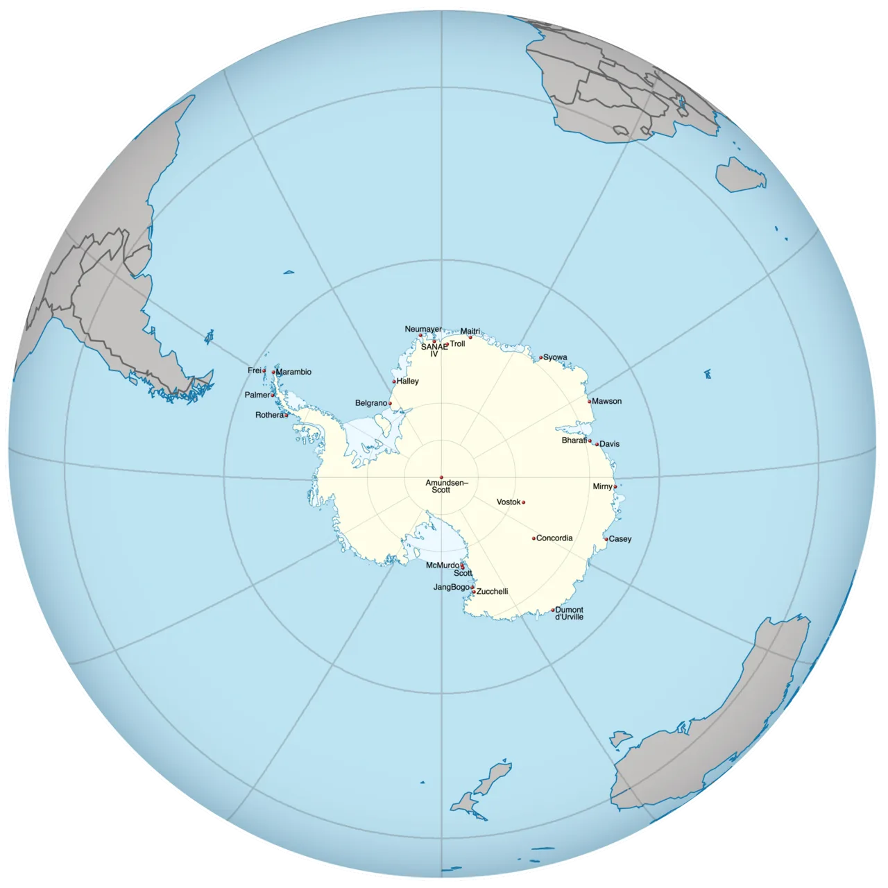

The comparatively petite West Antarctica sits under the West Antarctic Ice Sheet, flanked on either side by ice shelves floating on the ocean, like fluttering pelvic fins. The Ronne Ice Shelf faces the Atlantic, and the Ross Ice Shelf faces the Pacific. The Antarctic Peninsula whips toward South America’s southernmost tip, like a tail lashing at a predator. It hosts the relatively diminutive Antarctic Peninsula Ice Sheet.
Starting at the South Pole, every direction is north; lines of longitude serve as guides. Head along 0°—the Prime Meridian — and you’d head over East Antarctica, eventually encountering the Atlantic Ocean. The first major landmass you’d see: West Africa. Along 90° E, you’d have a different journey across East Antarctica, one that would take you over the Indian Ocean, to the south Asian country of Bangladesh.
Want to go north via the International Date Line at 180°? You’d cross the Transantarctic Mountains into West Antarctica, trek across the Ross Ice Shelf, and reach the Ross Sea. Keep going by boat and you’d be sailing through Polynesia. Heading 90° W would require another expedition over the Transantarctic Mountains and across West Antarctica. If you kept going, you’d travel up the eastern Pacific and skip all of South America before reaching the Central American country of El Salvador.
In Armadillo’s paper, the authors focused on a large slice of Antarctica spanning about 70° E to 160° E — the curve of coast from Prydz Bay to the Transantarctic Mountains. The study area reaches inland to 85° S — not quite to the South Pole, but only 5°, or less than 350 miles, away.
Big basins, little basins
Previous studies have determined that beneath the ice covering this pie-shaped piece of Antarctica lies a low-elevation sector sliced by north-south trending basins, many V-shaped in map view. “Until now,” Armadillo said, “these basins had generally been considered separately, rather than recognized as parts of a single fan-shaped system.” But when taken together, the low-lying swath of land comprises nearly half of East Antarctica.
Armadillo and colleagues analyzed the morphology of the land beneath the ice using software that extrapolates bed elevation and ice thickness using radio-echo sounding data. They also removed the effects of the massive weight of the modern ice sheet, modeling what an unburdened Earth would look like.
With this model, they traced the edges of the many V-shaped basins within this region by looking for variations in topography. In total, the team identified 30 basins that — like slices of pie — radiate outward from the continent’s interior, from near the South Pole.
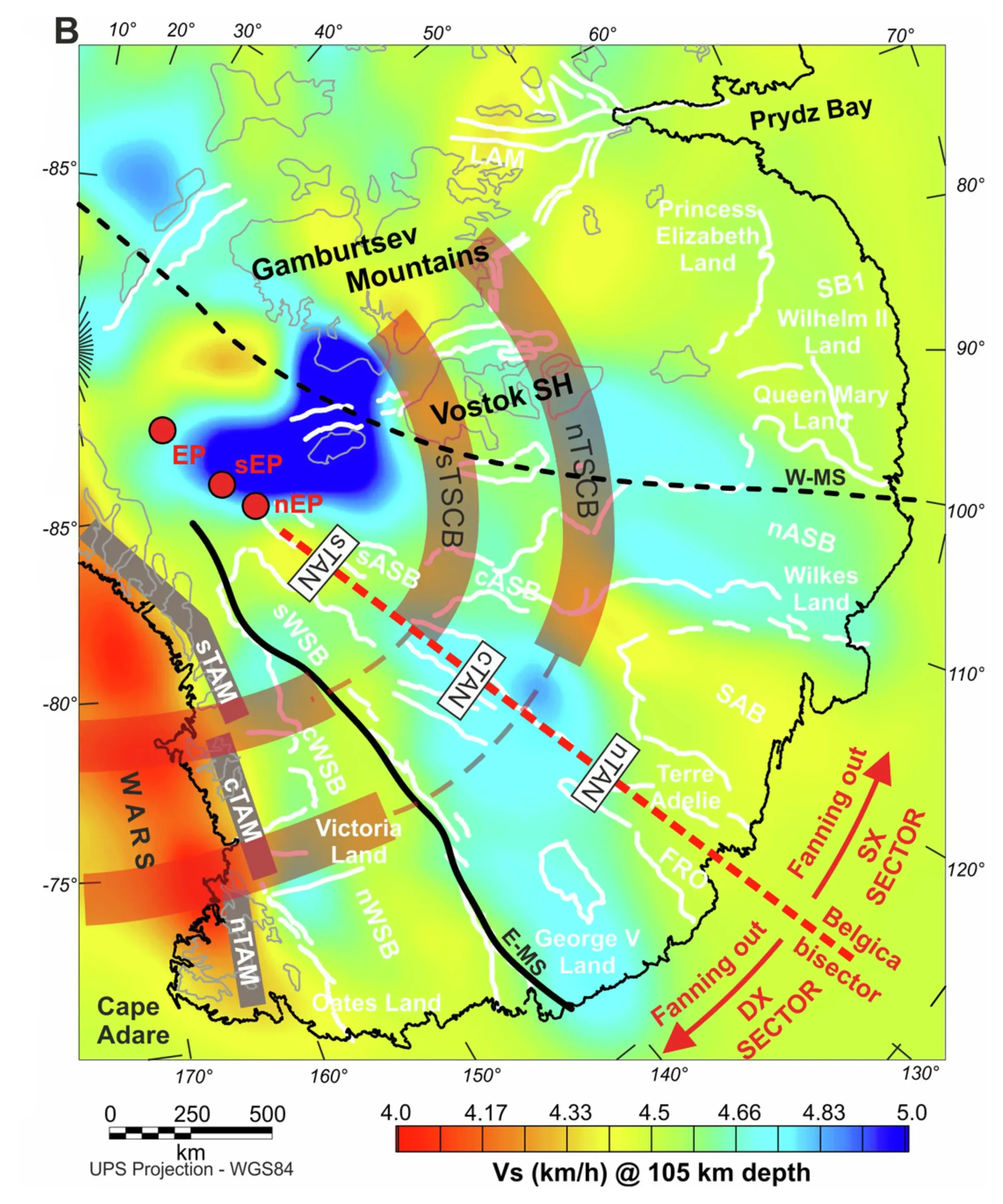
According to Armadillo and colleagues’ analysis, two first-order basins under the ice stand out — the Wilkes and Aurora basins, extending from relatively near the pole, reaching toward and beyond the coast. Curiously, these basins seem to be cut by two circular bands of east-west trending intraplate strike-slip faults (although the offset could be apparent). The Wilkes subglacial basin features apparent right-lateral offset, whereas the Aurora subglacial basin portrays apparent left-lateral offset. These basins are symmetric; they’re like mirrors of each other, reflected across the ridge that separates them — the Belgica subglacial highlands at 130° E, the longitude that cuts through western Australia. Moreover, only these two V-shaped basins extend from the center of the continent to offshore; other basins are confined to the continent, and more specifically to sections between the circular strike-slip belts.
Mountain-bounded slice, offshore offsets
The low-elevation region riven with basins is bounded on either side “by two of the least understood mountain ranges on Earth,” the authors wrote. Along 70° E, the mysterious subglacial Gamburtsev Mountains — of uncertain origin, with “unexpectedly youthful Alpine topography” — defines one boundary of the slice. The outside flank of the Gamburtsev Mountains is continuous with the Lambert Rift, through which the largest glacier on Antarctica, Lambert Glacier, flows. The rift (and glacier) continues into Prydz Bay.
The other side of the low-elevation region, along 160° E, is bounded by a swath of the Transantarctic Mountains, which form “the largest non-compressional mountain belt in the world,” the authors wrote. Unlike the subglacial Gamburtsev Mountains, the highest peaks of the Transantarctic Mountains poke above the ice, tracing the boundary between East and West Antarctica from the Weddell Sea, near the Ronne Ice Shelf, to beyond the Ross Ice Shelf and into the Ross Sea.
Where the circular belts that cross the newly defined East Antarctic Fan-Shaped Basin Province intersect the Transantarctic Mountains, the mountains appear right-laterally offset, forming three blocks. On the other side of the mountains, the West Antarctic Rift System in the Ross Sea continues this apparent right-lateral offset. At the vertex of the Wilkes Basin — its closest point to the South Pole — the Transantarctic Mountains turn by about 20° clockwise relative to their trend across half the continent.
Looking beyond Antarctica to the mid-ocean ridges that surround the continent, Armadillo and colleagues documented ridge segments offset in ways similar to what they observe on land. The segment that lines up with the Belgica highlands shows limited offset. On the east, offset mimics those in the Transantarctic Mountains. To the west, ridge offsets are more smoothly distributed or paused until the westernmost segment, near the Lambert Rift that lines up with the edge of the Gamburtsev Mountains.
Among the geophysical evidence supporting the existence of the East Antarctic Fan-Shaped Basin Province are studies of region’s lithosphere. For instance, a crustal depth model based on a combination of seismic and gravimetric data indicates thinned crust corresponding to the Wilkes and Aurora basins. Another study imaged low-velocity anomalies under the Wilkes basin and part of the Aurora basin — a finding that suggests a radial pattern of lithosphere that’s thin and weirdly warm.
Possible explanations
The symmetry present in the landscape and beyond likely reflects a common origin for the reflected structures. Possible culprits include glacial erosion or some version of extensional tectonics. Considering glaciers as the main driver for the landscape, the authors note that today’s ice velocities in this region are low. Moreover, geomorphic evidence from the past indicates that glaciers focused on eroding existing small-scale valleys — not continental-scale basins. “Glacial erosion has undoubtedly modified the landscape,” Armadillo said. “It cannot easily explain the coherent radial pattern across such a large part of the continent.”
Considering extensional tectonics, several possibilities emerge. Did one or more rifts propagating through the region create the observed pattern? “Rift propagation occurs in both continental and oceanic settings, and major rift systems lie near the edges of the fan-shaped province,” Armadillo said. “However, a simple propagating rift would not easily explain the province’s continent-scale symmetry.” The rifts may have helped localize deformation, but a broader process is needed to explain the overall geometry.
Did the region exploit pre-existing structures? Inherited structures, the authors say, could have influenced the location of faults. But — again — the continental-scale radial pattern suggests a mechanism operating at a broader scale.
The authors propose that the East Antarctic Fan-Shaped Basin Province formed through rotational extensional tectonics associated with the breakup of Gondwana. To explore this idea, they developed a kinematic model based on rotational extension with a mechanism akin to unfurling a hand-held fan, which the topography resembles. In this scenario, the two sides of the fan move away from a central arm that was fixed at pivot point near the South Pole.
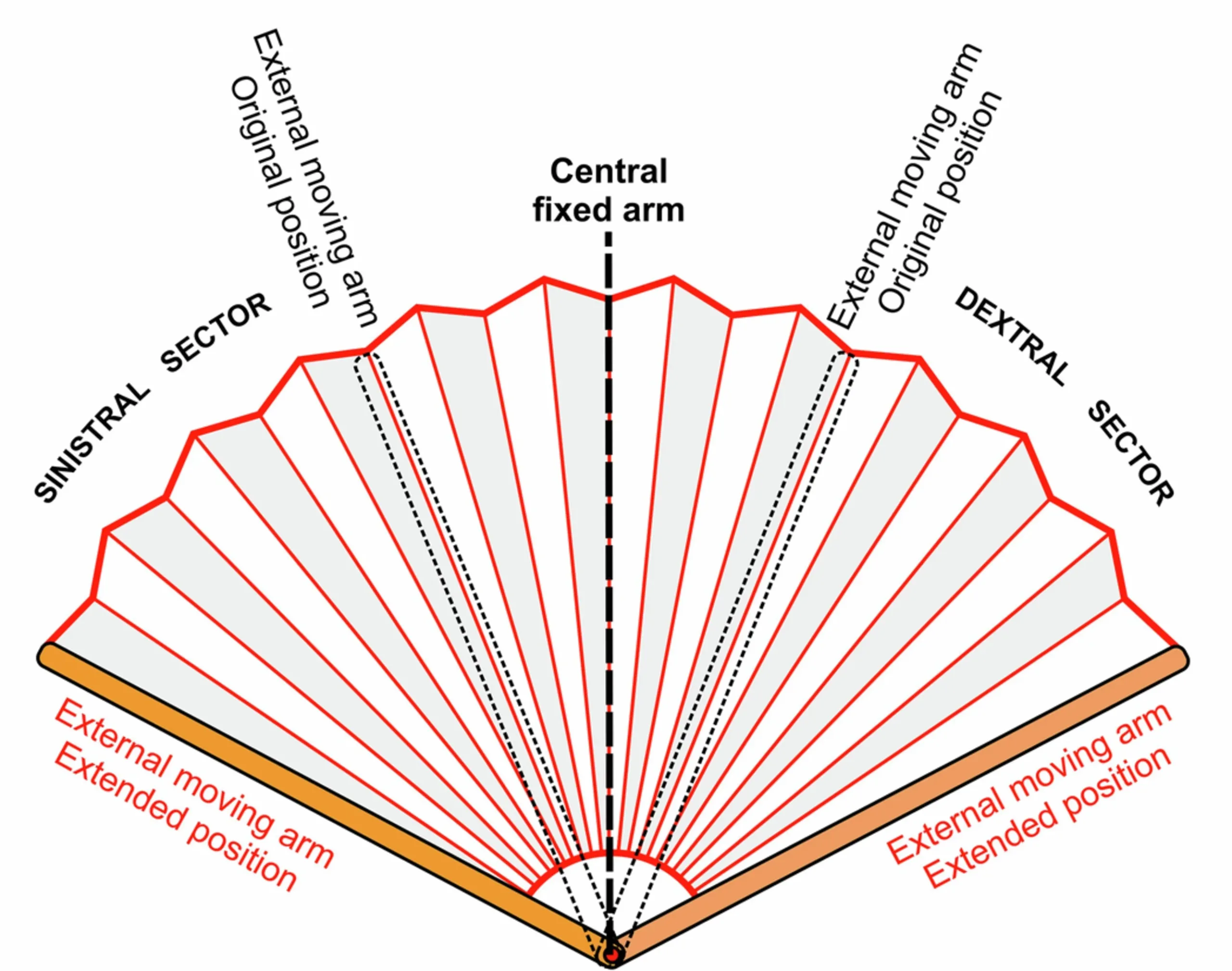
The fan would have opened from the Belgica highland — the fixed central arm. The counter-clockwise section became the Aurora basin, while simultaneous extension in the other direction formed the Wilkes basin. Extension would have continued, opening smaller, secondary basins. Breaks that initially controlled basin subsidence may have become zones of strike-slip motion.
Continental-scale consequences
As extension progressed, the Transantarctic Mountains would have become segmented, as would the Western Antarctic Rift System that’s now under the Ross Sea. The turn taken by the Transantarctic Mountains near the vertex of the continuously expanding Wilkes basin — the turn that is, today, 20° — would have begun. As the Transantarctic Mountains’ blocks overrode the hot mantle lithosphere associated with that rifting, those blocks would have experienced differential uplift in both time and space. This could, in fact, be one reason for the unusually high peaks in this part of the range, although it is not the sole cause, Armadillo said.
On the west side, toward the subglacial Gamburtsev Mountains, rotational extension is less pronounced. This may result from lithosphere that was originally much thicker — the proposed Mawson continent that linked East Antarctica and South Australia before they separated. The existence of the strong Mawson continent may have caused deformation to concentrate in certain plates, leading to landforms like Lake Vostok — the largest subglacial lake in Antarctica — and massive Lambert Rift. Even the youthful topography of the Gamburtsev Mountains may have been influenced by this extension, which could have contributed to the range’s uplift.
The northern, curved edge of the fan formed the lithospheric weakness that controlled the separation of Australia from Antarctica, which completed Gondwana’s breakup. Pull-apart basins between strike-slip faults may have developed into seafloor-spreading segments that would eventually push the continents apart. The result today: semi-circular passive continental margins of both Antarctica and Australia.
Ice today
“The hidden fan shows that Antarctica’s ancient and modern histories are closely connected,” Armadillo said. Moreover, he pointed out that “major deformation does not occur only at the edges of tectonic plates.”
The model of rotational extension requires that stresses be transmitted far into the continent, “where differences in strength and thickness of the crust and lithosphere may focus deformation.” Just look to the two sides of the province: the Transantarctic Mountains were rotated, divided, and uplifted, whereas the thicker, strong lithosphere on the other side may have helped to shape the Gamburtsev Mountains. What’s more: The same underlying, continental-scale process may have been the driver for the disparate development of these two remarkable yet poorly understood ranges.
Tectonic processes reshaped the continent tens of millions of years ago, before the ice sheets formed. The ancient structures — basins, rifts, and faults — function today as guides for glaciers and subglacial water, sending them seaward. “Understanding this buried landscape may therefore help [us] reconstruct the breakup of Gondwana and improve models of how the East Antarctic Ice Sheet could respond to future change,” Armadillo said.
Additional measurements about what’s happening beneath the ice could help scientists determine when the fan-shaped province began to form, and its subsequent development. “The idea is still a model,” Armadillo said, “not the final word.”
This study utilized a seismic velocity model of Antarctica in the NSF National Geophysical Facility data archive.