

Near-surface geophysics is like getting an X-ray of the shallow Earth—without digging. By measuring subtle changes in gravity, magnetism, electrical properties, and seismic vibrations, scientists can “see” buried layers, water, ice, tunnels, and contaminants hidden beneath our feet. These tools help answer everyday questions—Where is groundwater? Is a slope stable? What’s under this road or farm field? It can support safer construction, cleaner environments, and a better understanding of the landscapes we live on.
Electromagnetic methods
Electromagnetic (EM) instruments send out electromagnetic signals (or listen to natural ones) and measure how easily the subsurface conducts electricity, which depends on things like water content, salinity, clay, and buried metal — often quickly, and without disturbing the ground
Applications include: locating groundwater; tracking contamination; finding buried infrastructure, forensic, and archaeological sites; and mapping sediments, faults, and permafrost.
Specific methods include: electromagnetic conductivity, electrical resistivity topography (ERT), ground penetrating radar (GPR), magnetotellurics (MT), and transient electromagnetics (TEM).
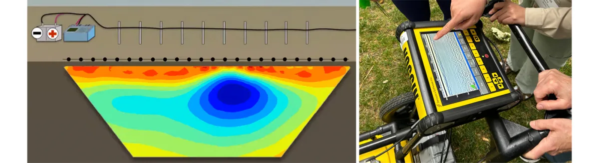
Credit: EarthScope / Beth Pratt-Sitaula
Geodetic imaging
Geodetic imaging methods measure subtle changes in Earth’s surface shape, elevation, or position to reveal what’s happening below or across the landscape. By using precise satellite, uncrewed aerial systems (i.e., drones), or ground-based sensors, these techniques track motion, deformation, and surface patterns that signal processes like groundwater changes, landslide movement, volcanic activity, and fault slip.
Applications include: monitoring natural hazards; mapping land subsidence; assessing glacier and snowpack changes; and studying tectonic deformation.
Specific methods include: GPS/GNSS, InSAR, lidar, and structure from motion photogrammetry (SfM).
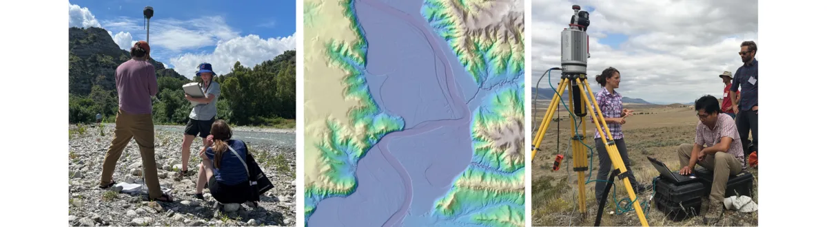
Credit: Sean Gallen / OpenTopography / Beth Pratt-Sitaula (EarthScope)
Gravity
Gravity methods measure tiny variations in Earth’s gravitational pull to detect changes in density underground—without digging. Because rock, soil, water, and voids have different densities, gravity surveys can help “see” buried structures and track mass changes over time.
Applications include: mapping bedrock depth and sediment thickness; locating cavities, sinkholes, and buried channels; monitoring groundwater and glacial changes; and supporting volcanic and geothermal studies.
Specific methods include: ground-based gravimetry, satellite gravimetry, and time-lapse (microgravity) monitoring.
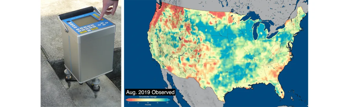
Credit: Wikipedia / NASA
Magnetometry
Magnetometry measures tiny variations in Earth’s magnetic field to detect magnetic minerals in rocks and man-made metal. Because different materials have different magnetic properties, magnetic surveys can map hidden geologic features and locate buried objects.
Applications include: finding buried pipes, drums, and unexploded ordnance (UXO); locating archaeological features; mapping lava flows, dikes, and faults; and outlining shallow bedrock and sediment patterns.
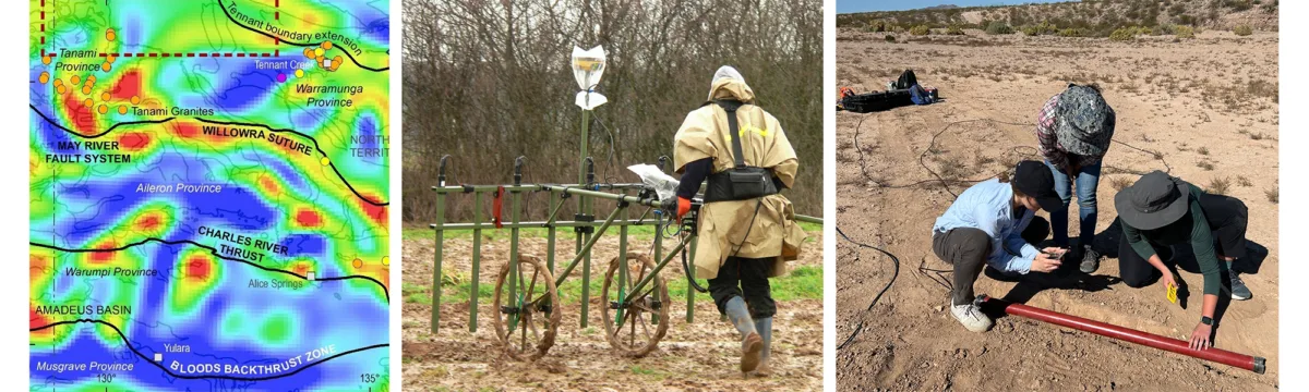
Credit: Roman Křivánek / Wikipedia / Beth Pratt-Sitaula (EarthScope)
Seismic and acoustic methods
Seismic and acoustic methods use sound waves to “image” the subsurface by sending vibrations into the ground (or listening to natural/ambient noise) and measuring how waves travel through different materials. Because wave speed and signal strength change with rock type, fractures, water content, and stiffness, these surveys can map layers and detect weak zones without excavation.
Applications include: mapping depth to bedrock and sediment thickness; locating faults, voids, and fractures; assessing site conditions for construction and earthquake hazards; and detecting seepage, thawing permafrost, or changes in groundwater.
Specific methods include: distributed acoustic sensing (DAS), infrasound, passive seismic, seismic refraction, and seismic reflection.
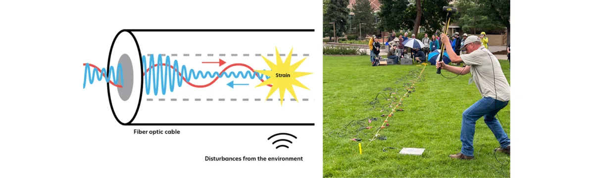
Credit: Davie Loria / Beth Pratt-Sitaula (EarthScope)
Spectral and Thermal Imaging
Spectral and radiometric remote sensing methods use aircraft, uncrewed aerial systems (i.e., drones), or satellites to measure light and energy emitted or reflected from the ground — revealing material “fingerprints” and surface conditions without contact. Different minerals, soils, vegetation, moisture levels, and temperatures produce distinctive spectral signals, while natural gamma radiation helps map near-surface chemistry.
Applications include: mapping minerals and altered ground; identifying soil and vegetation stress; tracking moisture and seepage; detecting active faults and geothermal/volcanic heat; and characterizing surface materials for geologic and environmental studies.
Specific methods include: multispectral imaging, hyperspectral imaging, thermal infrared (TIR) imaging, and gamma-ray spectrometry.