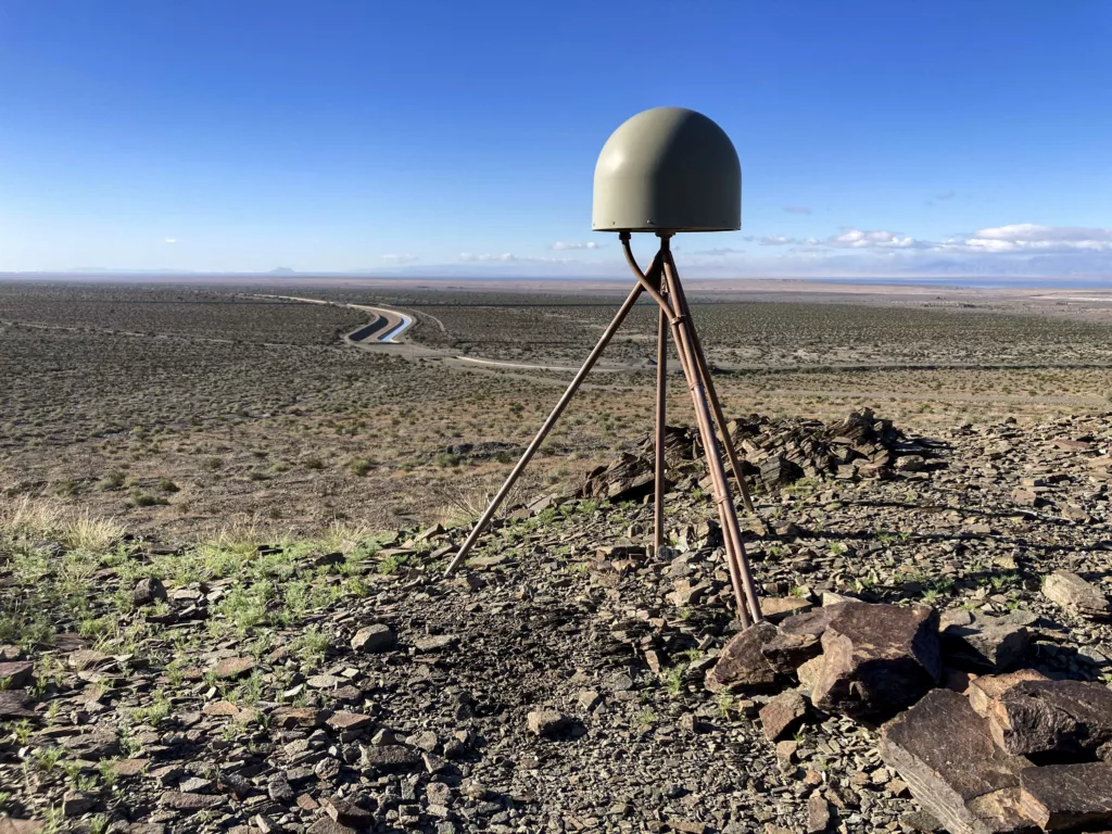
We recently saw the culmination of a long-running partnership between the USGS, EarthScope, and university partners—GPS sensors are now part of the ShakeAlert® Earthquake Early Warning System.
This milestone comes after the USGS certified an algorithm that was tested in parallel to the live system for over a year. The algorithm determines how the ShakeAlert system uses GPS data to augment data from seismometers, significantly improving the system’s ability to accurately detect the largest earthquakes. The NSF GAGE Facility operated by EarthScope Consortium is responsible for the flow of this GPS data into the ShakeAlert system.
Earthquake early warning systems have traditionally been built on networks of seismometers, which measure shaking caused by passing seismic waves. GPS sensors (technically termed GNSS when they utilize more than just U.S. navigation satellites) are different in that they can instead measure the total extent of ground movement.
Why add GPS sensors?
During the largest, most destructive earthquakes, seismometers near the epicenter can saturate—like a highly sensitive microphone recording a very loud sound. This can add delay to accurate estimates of the earthquake’s magnitude. But while GPS sensors aren’t useful for earthquakes that are too small or too distant, they don’t saturate during large earthquakes. GPS sensors just move farther, providing an immediate indication of the earthquake’s magnitude. This provides critical information for delivering alerts to areas estimated to experience strong shaking.
The 2019 magnitude 7.1 Ridgecrest, CA earthquake provides an example. A 2020 study found that real-time GPS data from sensors nearby—of which there were many—could have been used to estimate the magnitude at 6.9 within 13 seconds. As another 2020 study explored, the ShakeAlert system estimated that earthquake at magnitude 6.3 within 22 seconds but did not quickly revise the magnitude upward as more data came in. At this stage the ShakeAlert system was still in the process of being tested—public alerting started in California later in 2019 and in Oregon and Washington in 2021. Improvements were made to the ShakeAlert system based on the lessons learned from the Ridgecrest earthquake, which now include the addition of GPS to help ensure ShakeAlert performs well in larger earthquakes.
Incorporating GPS is also relevant to the tsunami hazard associated with the largest earthquakes along subduction zone boundaries like the Pacific Northwest. This was demonstrated during the 2011 magnitude 9.1 Tohoku earthquake in Japan, when the early warning system underestimated magnitude and the incoming tsunami. The incorporation of GPS station data could have improved system performance—and this has since been developed in Japan.
GPS instrumentation
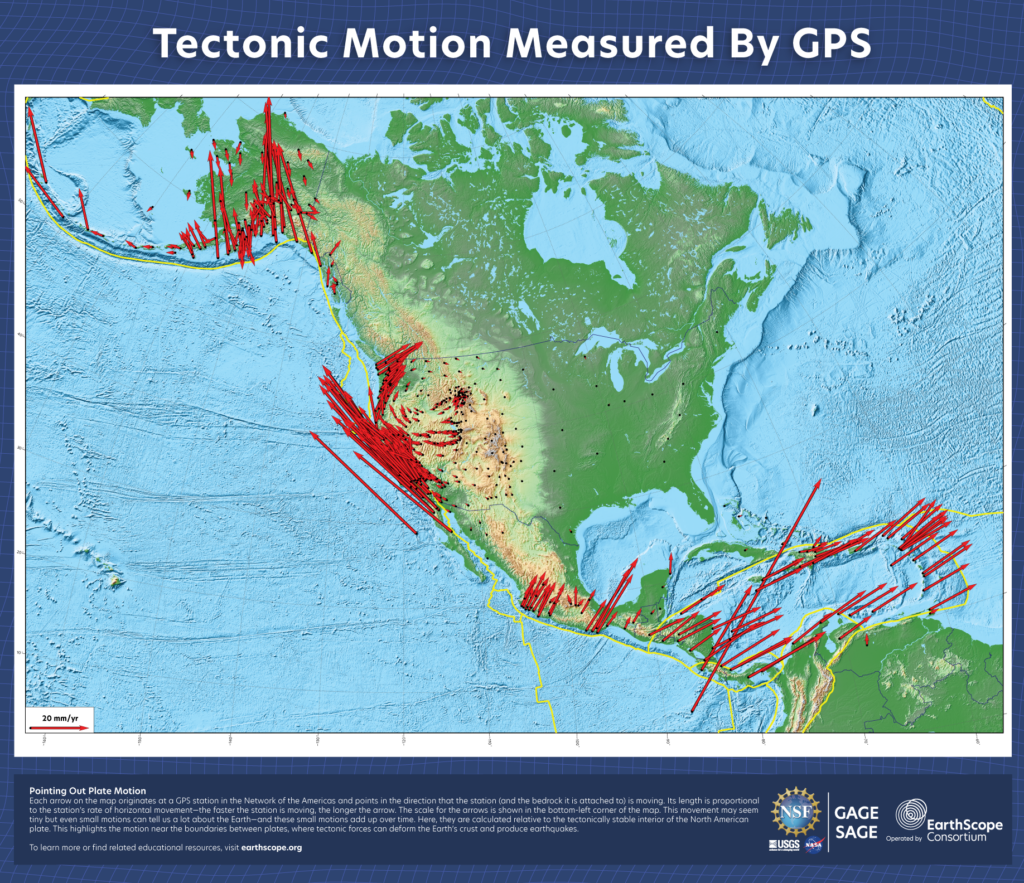
In additional work supported by the USGS, EarthScope also added several GPS stations to the Network of the Americas to fill in coverage gaps along the Oregon coast for Cascadia subduction zone earthquakes. Additionally, over 180 stations in the network received upgrades. This included some equipment upgrades, like new GNSS receivers capable of using more satellites and new cell modems to improve data transmission. It also included enabling Precise Point Positioning corrections for each receiver, reducing noise in the data and enhancing the ability to measure earthquake displacement in real time.

The Network of the Americas is part of the NSF GAGE Facility operated by EarthScope, and includes over 1,100 continuously operating GPS stations from Alaska to the Caribbean. EarthScope maintains the stations in this network as well as the data processing, archiving, and distribution systems, with the help of data analysis partners at Central Washington University and the Massachusetts Institute of Technology. The current effort to migrate these data systems to cloud operations provided a good opportunity to build a new low-latency, robust architecture to deliver GPS data to the ShakeAlert system in real time.
With that data stream now contributing to ShakeAlert, the system is even more capable of fulfilling its purpose—providing valuable seconds for protective actions that can help keep people safe.
Educational Resources
Find more information, videos, and relevant classroom resources at earthscope.org/ShakeAlert.
About ShakeAlert
ShakeAlert is not earthquake prediction. Rather, the USGS-operated ShakeAlert Earthquake Early Warning system detects an earthquake that has already started and estimates its location, magnitude, and shaking intensity. If an earthquake becomes large enough to meet USGS alert thresholds, a ShakeAlert Message is issued. Then, technical partners, which have entered into a license agreement with the USGS, use this information to produce and deliver an alert that prompts people to take a protective action, such as Drop, Cover, and Hold On, and/or to trigger an automated action that can protect vital systems, equipment, facilities, and infrastructure. These automated actions could include slowing a train, closing valves, issuing a public announcement, and many others.
ShakeAlert is currently available in California, Oregon, and Washington, serving over 50 million residents and visitors in those states. Learn more at usgs.gov/ShakeAlert.
A USGS news release on this announcement can be found here.
About EarthScope Consortium
EarthScope Consortium is a non-profit consortium dedicated to supporting transformative global geophysical research and education. Formed from a merger of IRIS and UNAVCO in 2023, EarthScope operates the NSF GAGE and SAGE Facilities. The organization supports Earth systems science and its applications by providing cutting-edge geophysical instrumentation and data, along with resources for education and workforce development of the next generation of scientists.
Media requests can be submitted through our Contact Us page.

