


Imagine you could observe a hurricane as it makes landfall by using the same methods as seismologists — by listening to waves rippling through the environment around you.
This is exactly what a team led by Dr. Qing Ji, a postdoctoral researcher at the UT Austin Jackson School of Geosciences, has done. In a Science paper released in August, Ji and his collaborators leveraged archival data from US Transportable Array seismoacoustic stations in Louisiana to detect the structure and passage of a landfalling hurricane.
One array, many uses
When the US Transportable Array project (TA) was operated from 2003 – 2021 to help image the interior of North America with seismometers, hurricane monitoring wasn’t on the list of scientific applications. The project was a massive effort to move broadband seismometers piecemeal across the United States and parts of Canada and Mexico. Like laying out strips of cloth for a quilt, portable seismometers were installed temporarily in moving rectangular arrays with 75-km spacing, providing dense coverage for high-resolution sensing. The goal was to measure earthquakes, and use the information gleaned from seismic energy to sculpt a subterranean image of the continent.
Mid-project, more capability was added to these stations — pressure, infrasound, and meteorological sensors were installed, helping stations measure phenomena from atmosphere to earth’s interior.
Hurricane formation
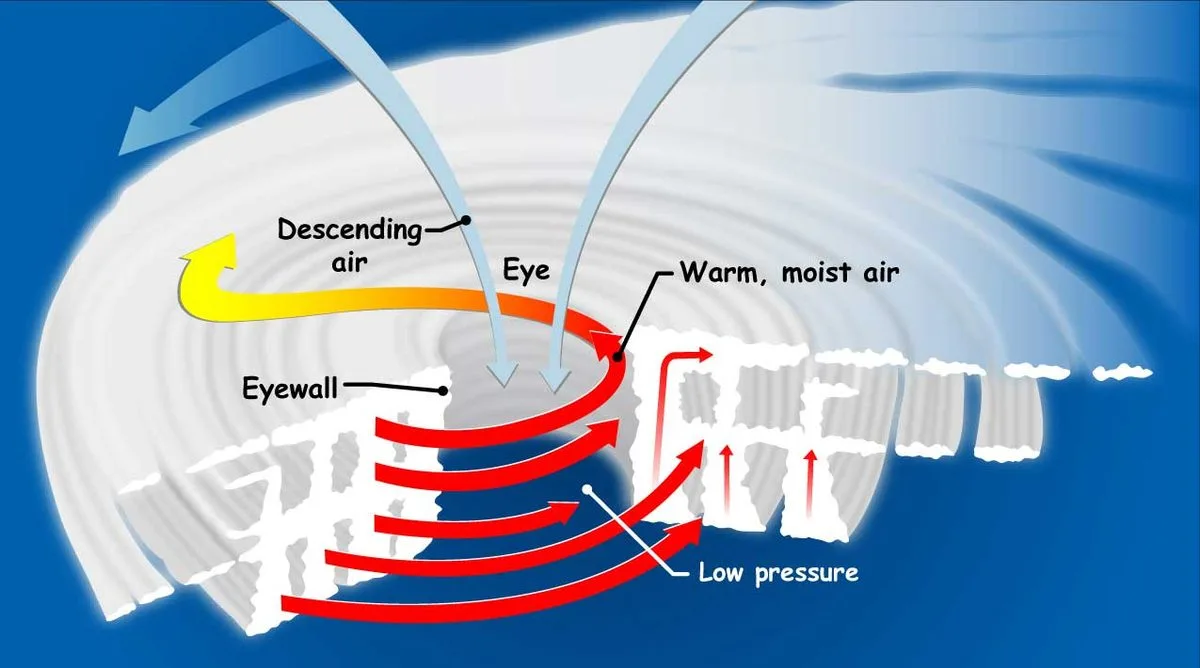
It might seem far-fetched to use seismic stations to monitor hurricanes, an occurrence solidly in the realm of atmospheric science, but it’s quite ingenious. Hurricanes (or typhoons in the western Pacific) are partially the product of intense and sustained atmospheric pressure lows. These swirling monsters form in warm waters during the end of meteorological summer, when ocean temperatures are at their highest. As the water temperature surpasses 80 F, the air above begins to rise, creating a low pressure pocket underneath. This unlocks a runaway effect: air from above then rushes inward to fill this pocket, creating a vortex of moisture, wind, and energy.
The structure of a hurricane is also continuously shaped by pressure differences. As these furious storms barrel across the ocean toward land, their centers — referred to as “the eye of the storm” — remain the lowest pressure zone relative to their outer stormy rain bands. And this pressure difference can be detected by seismic equipment.
Waves are everywhere
That’s because the types of mechanical waves that are detected by seismometers — typically elastic waves — can also be caused by sound waves. Sound reaches our ears as a series of pressure waves, which stretch and squeeze the air molecules. This same stretching and squeezing exerts force on the earth when pressure waves meet the ground and propagate through, creating seismoacoustic waves. They can be detected using seismometers or infrasound sensors, depending on the frequency. Infrasound refers to very long-period sound waves that are below the threshold of human hearing. They’re generated by a variety of natural events, from earthquakes to severe, stormy weather — like hurricanes. In the case of a hurricane, low-energy pressure waves can be recorded as surface pressure fluctuations by infrasound sensors, while the force transferred by these pressure waves to the ground can be detected by seismometers.
Listening to the environment
Ji’s team used data from TA stations along the Gulf Coast that recorded data during Hurricane Isaac’s landfall in August 2012. Isaac was a tropical storm that evolved into a Category 1 storm as it neared the coast. Several states — Texas, Louisiana, Mississippi, Alabama, and Florida — all experienced several inches of rain, hurricane-force winds, and ultimately just over three billion dollars of damage as a result of Isaac. While not the most destructive storm of the 2010s, it occurred at just the right moment for TA stations, equipped with seismometers, infrasound sensors, and meteorological monitors, to detect several strands of evidence that marked Isaac’s landfall.
Smooth moves
But what does the Transportable Array add to hurricane monitoring? Atmospheric scientists in the business of hurricane tracking rely on complex methods to measure the hurricane boundary layer — possibly the most important component for understanding how a hurricane will evolve. The HBL is the lowermost 1 – 2 km of the atmosphere where turbulence starts to influence a hurricane’s development. Hurricanes thrive when roughness from terrain is minimized, such as over the ocean surface, and will weaken substantially when terrain like land, buildings, and mountains are encountered. But warm waters and high convergence of air will sustain a hurricane — causing wind speeds to increase, the eye’s pressure to fall further, and ultimately the hurricane to intensify. To measure the HBL’s pressure and wind speed, either portable towers, radar, or aircraft must be flown into the storm to take readings. These methods introduce considerable problems, such as bodily harm to personnel tasked with piloting a stormfaring plane, to availability and longevity of monitoring instruments.
So with TA stations already in place and equipped with sensors applicable to hurricane monitoring, archival TA data presents a new, safer opportunity to complement these existing methods.
Landfall
In 2012, TA stations had been installed along the Gulf Coast and were reliably taking data. As Isaac approached the coast on August 29, station TA.645A began to record evidence of the hurricane as long-period pressure and broadband infrasound signals.
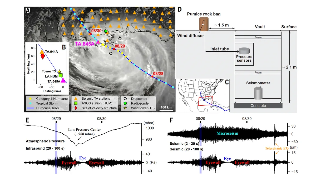
As Isaac inched closer to the coast near TA.645A, the infrasound sensor detected surface pressure fluctuations up to 40 Pa, a clear sign of the eyewall’s approach. The eyewall is the strongest part of a hurricane, where wind speeds are at their highest and heavy rain is fueled by towering thunderstorms. This is where the most damage upon landfall is typically accrued.
Isaac’s eye passed just 4 km away from TA.645A midday on August 29, and infrasound pressure dropped to 0 Pa. The station’s barometer recorded a low pressure zone of ~968 mbar, which roughly matched other empirical barometric readings of the eye, strongly indicating that the infrasound data accurately captured surface pressure changes caused by the eye’s passage.
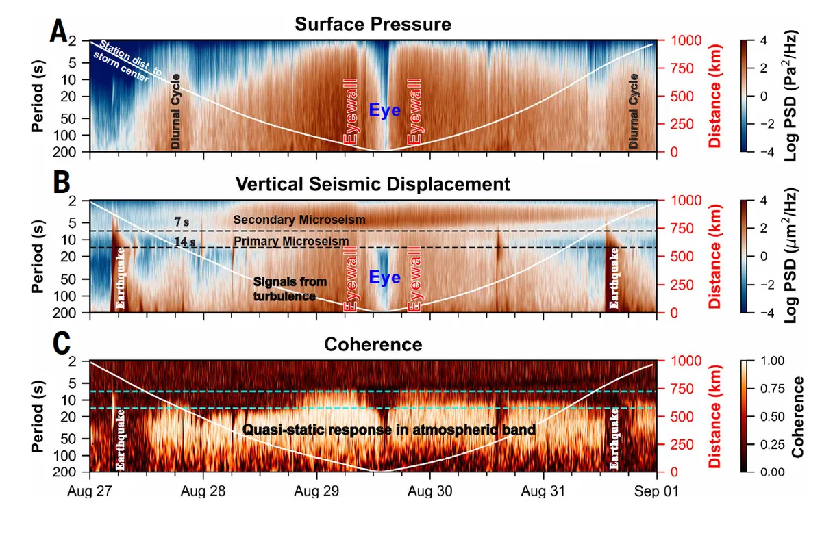
TA stations, obviously, are equipped with seismometers. So what did the seismic readings indicate? Both short period and long period signals were detected, but the long period showed the clear fingerprints of Isaac. These signals indicated vertical ground displacements on the order of ± 15 microns as the eyewall passed near TA.645A — movement comparable to the width of human hair. Moreover, the data displayed high coherence between pressure and displacement. In other words, that the pressure fluctuations likely directly caused the ground displacement.
The final leap
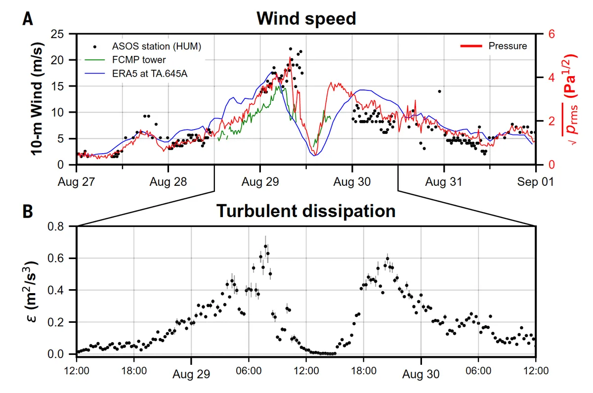
But the team could go one step further and use the infrasound pressure data to illuminate conditions within the hurricane boundary layer. As it turns out, infrasound pressure readings are correlated with independent measures of 10-meter wind speed, which in turn can help characterize turbulence. So where direct measurements or reanalysis products of wind speeds are sparse, missing, or of poor resolution, infrasound pressure fluctuations can act as a stand-in.
Altogether, the serendipitous location of seismoacoustic stations revealed the ability to capture hard-to-resolve characteristics of hurricanes. Ji’s team contends that placing these typically geophysical instruments at other scientific monitoring network stations with meteorological capabilities, or vice versa, can help a variety of earth scientists creatively measure phenomena that would otherwise be difficult to capture.
While the Transportable Array is no longer active, data from the project remains archived by the NSF National Geophysical Facility, allowing researchers to return to data with new insights and new scientific questions. Infrasound sensors and seismometers are, of course, located at many geophysical network station sites to listen for tremors from earthquakes, tsunamis, and volcanoes, and this new work demonstrates their use to go beyond the traditional uses. But this does not mean traditional methods of hurricane monitoring — radar, eyewall flights, and portable radio towers — are now defunct. Rather, this presents the possibility of enhancing the available toolbox with networks that already exist.