

Geothermal energy is an up-and-coming natural resource, with many jurisdictions looking to diversify energy sources.
Geothermal refers to heat energy within the Earth being harnessed for energy needs. Resources often come from volcanic areas, where hot magma interacts with groundwater to create hydrothermal reservoirs. (Although designs known as “enhanced geothermal systems” are targeting much broader settings.)
The first step to understanding the viability of a geothermal source comes from basic prospecting of the source itself — how large it is, what the controlling mechanisms are, and how reliable of a resource it will be in the long term.
Exploratory surveys of geothermal resources can be invasive, typically requiring the drilling of wells and boreholes that may show that a potential site won’t pan out for use, but one way to understand the structure of a resource is to use seismic stations.
A recent example of this non-invasive approach is at the Aluto geothermal complex in Ethiopia.
Aluto is a volcanic complex in the northern part of the continent-stretching East African Rift System. It’s the result of the overlying crust being torn apart by the opposite motions of the Somalian Plate and the Nubian Plate, making it easier for the mantle below to bubble up to the surface in the form of a volcano.
While the volcanic complex is relatively understudied from an academic standpoint, regional utilities have investigated the Aluto geothermal field for its potential as a source of energy since the 1970s. In fact, it’s the only operating geothermal energy site in Ethiopia.
While previously studied to an extent, researchers remain keen to understand more about what feeds the volcano to inform longer term resource usage–and seismic data can help.
In a new article in the JGR Solid Earth journal, researchers used historical seismic data from the Aluto geothermal field to construct a better picture of what lies beneath the volcano.
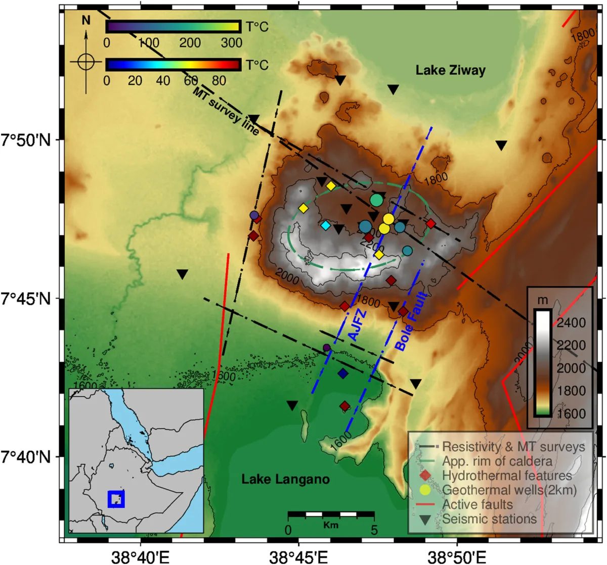
Data was taken from a network of 12 seismometers located around the volcano and surrounding rift zone. The stations cover an area roughly 20 x 20 km, giving high resolution for capturing even small seismic events. Readings from between January 2012 and January 2014 were pulled for this study from the NSF SAGE data archive operated by EarthScope. Then, an algorithm called QuakeMigrate was used to identify seismic events that may have previously been missed, potentially due to smaller magnitudes or because they happened at depth.
As a result, more seismic events at depths greater than 9 km were discovered. In fact, the seismicity extends to around 40 km — much deeper than previously detected and in contradiction to geochemical models of the geothermal field which suggested a magmatic body much closer to the surface.
Moreover, there seemed to be a cyclic seismic signal correlated with the region’s rainy season. More seismic events were detected two to three months after the region’s peak rainy season than during the dry season.
This isn’t surprising. In many rift systems such as the East African Rift, precipitation and groundwater are connected to a volcano by the presence of extensive faulting. The East African Rift System is composed of a series of N-S-oriented normal faults, which allow fluids such as water from the surface or superheated water that interacts with magma below to seep into the crust. The fluids, therefore, make the fault surfaces more slippery, and the timing of the wet season directly causes more fault movement. This finding provides new insight into how the seismicity of the Aluto geothermal field is influenced by climate–not just by a rifting tectonic regime.
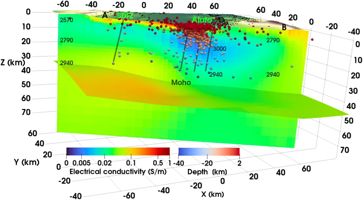
Additionally, by combining seismicity from this study with previous magnetotelluric survey results of the region, which reveals the conductivity of materials below the surface and serves as a proxy for temperature, it’s likely that a “mushy” semi-crystallized magmatic body is present just north of the previously identified magmatic intrusion and is responsible for off-rift volcanoes. Its presence provides an intriguing opportunity for further geothermal resource exploration.
The presence of the mushy magma body is further supported by “b-values” for the region. A b-value, or the Gutenberg-Richter law, is a number that describes the relationship between a region’s frequency of earthquakes and their magnitudes. Typically, b-values are around 1.0. At Aluto, the value is nearly 2.0.
A high b-value like this is typically associated with volcanic regions due to the presence of fluids beneath the surface. In the case of Aluto, the b-value suggests that these fluids are likely part of a coupled magmatic-hydrothermal system.
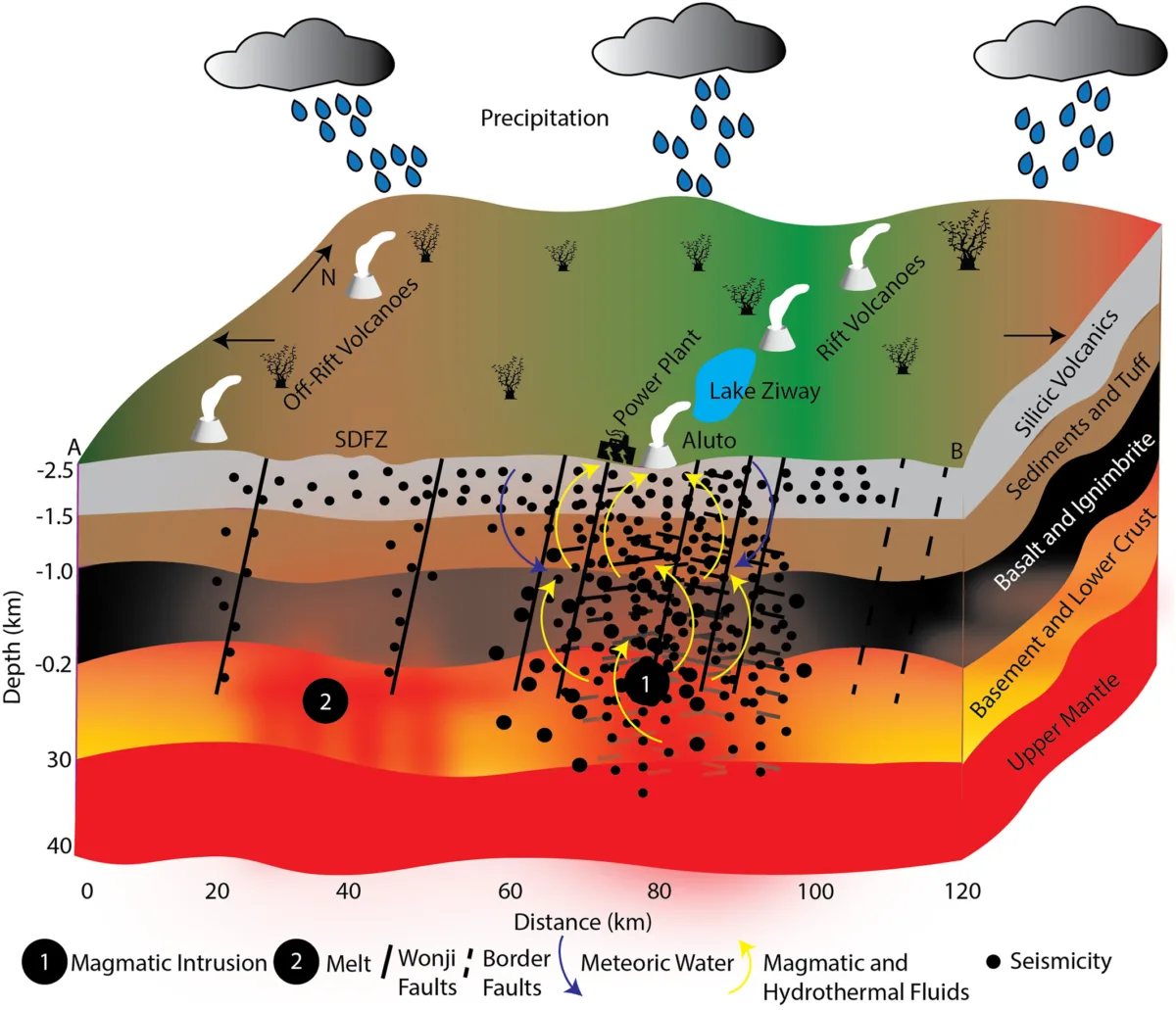
Considering all the new and old results, the unrest at Aluto is most likely due to fluids rising through and along already-stressed faults, but from a much deeper source than previously thought. Aluto is therefore driven by a combination of processes within its caldera and surrounding regional structures serving as conduits for hydrothermal fluids to the surface.
At this geothermal site, the additional analysis of microseismic events over a historical instrumental record has revealed much more information about Aluto’s source and seasonal behavior — all without having to invest in more instrumentation or exploratory surveys. Archived seismic station data can provide opportunities for new findings for decades, informing both studies of how Earth works and (in this case) resource exploration.