

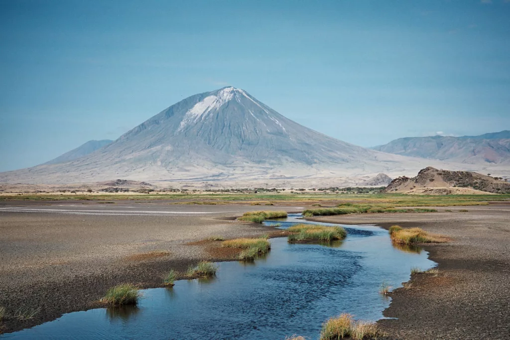
Down at the southern end of the East African Rift in Tanzania lies the Ol Doinyo Lengai volcano, exceptional in that it is the only active volcano that erupts carbonatites—igneous rocks composed of >50% carbonate minerals. Ol Doinyo Lengai experienced multiple eruptive episodes with ash and lava flows from 2007-2010, causing damage to nearby communities. Until recently, the plumbing mechanisms beneath the volcano remained largely a mystery in part because it is remote and access is difficult. Researchers are now using InSAR data and GNSS instruments to reveal that Ol Doinyo Lengai might be fed by a multi-reservoir magma plumbing system.
A magmatic plumbing system is a series of connected magma storage areas and feeder intrusions that move magma from deeper sources to shallower dikes, sills, and magma reservoirs in the crust. Understanding the specific plumbing mechanisms of Ol Doinyo Lengai allows researchers to evaluate the most likely type of eruption in the future, which in turn can better prepare local communities for the next eruption.
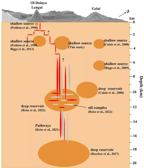
A May 2023 study published in the Journal of Volcanology and Geothermal Research details the recent findings of a research team, led by Ntambila Daud, an assistant lecturer at Ardhi University, on the probable inner workings of the plumbing system beneath the Ol Doinyo Lengai volcano. The team used the TZVOLCANO GNSS network, as well as InSAR data, to analyze the detectable surface motion. It took a number of years to set up the GNSS network, due largely to logistical obstacles. However, the team prevailed, establishing the TZVOLCANO network to detect surface deformation at the volcano as well as fault slip on the adjacent Natron Fault. The network contains four stations, each of which transmits data in real time.
The research team chose to use both GNSS and InSAR because the datasets maintain different strengths; while GNSS provides continuous three-dimensional observations of the surface with millimeter precision, its spatial coverage is scattered. InSAR, on the other hand, provides better spatial coverage in two dimensions, but only passes over an area to collect data a few times each month. In synthesizing the data from both systems, the research team found results suggesting that an offset shallow (and currently deflating) magma source is present between Ol Doinyo Lengai and another dormant volcano called Gelai. Additionally, the results suggest a second, deeper magma reservoir that feeds the shallower magma source, a suggestion consistent with previous geodetic studies. The team also concludes that the shallow reservoir may be connected to the active crater via a network of small fractures.
Although more data could paint a clearer picture, this study provides valuable information for risk assessment in the local area. Ol Doinyo Lengai’s unique low-silica lava composition decreases the viscosity of the lava, resulting in some of the fastest flowing lava in the world. The volcano has proved an important tourist attraction, fueling the Tanzanian economy while simultaneously contributing to local economies and prompting nearby village expansion. Thus, risk assessment becomes paramount in its importance to maintain the safety of tourists and locals near the volcano. Information and data from this study provide the foundation for better understanding of Ol Doinyo Lengai’s magmatic plumbing system, ultimately leading to better estimates of future eruption types.
The GAGE Facility, operated by EarthScope, provided instrumentation and data archiving support for this research.