

The metaphor of a “slippery slope” is often invoked for things that might quickly get out of control, but in glaciology these words can be applied more literally. One of the factors governing the flow of a glacier is the conditions at its base—ice moves more slowly over frozen ground than it does over soft, wet sediment.
In a warming world, we want to know how quickly ice sheets can melt and raise sea level. If melting ice lubricates the base and speeds up ice flow, losses could accelerate. That makes this process an important one to understand. A new paper led by the University of Oxford’s Laura Stevens presents GAGE-supported research on Greenland’s Helheim Glacier focused on this question.
Just as the visible landscape can hold streams and lakes that carry surface water, the area hidden beneath a glacier can include a drainage network through which meltwater can flow downhill or infiltrate into the ground. This drainage network could be “efficient”—swiftly transporting meltwater away—or it could be “inefficient”, in which case a sudden delivery of meltwater could pond up and change the conditions governing the glacier’s speed.
And sudden deliveries do happen. During the warm season, lakes of water form on top of the ice in Greenland. They can suddenly drain downward when a pathway opens, like pulling the plug in a bathtub.
Because satellites can constantly measure the movement of glacial ice throughout Greenland, scientists have attempted to understand this behavior based on changes in glacier velocity. Farther inland, glaciers that slow down near the end of the melt season are thought to have efficient drainage networks (because the amount of lubricating meltwater at the base quickly diminishes), while glaciers that maintain constant velocity would have inefficient drainages that store meltwater longer and change more slowly.
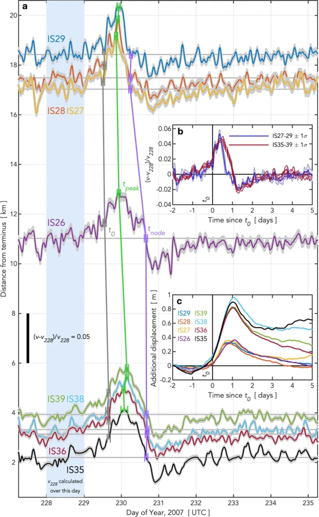
In order to see whether this is true for the faster-flowing coastal glaciers that flow directly into the ocean, the research team set out an array of GPS instruments on Helheim Glacier in 2007. Some were located near the bottom of the glacier, and others were located farther up near an area where meltwater lakes form. On August 17, one of those lakes drained away, sending something like 9 million cubic meters of water down through the ice.
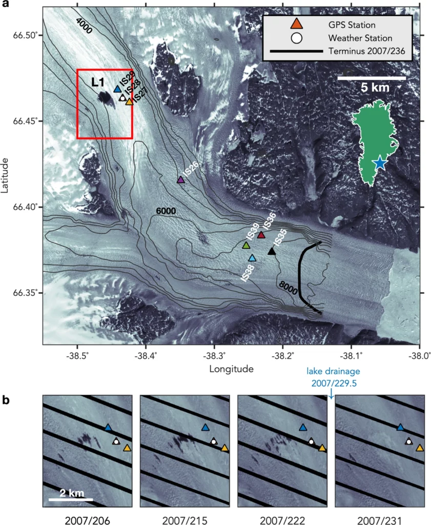
The GPS instruments show that the glacier sped up by about 4% over the course of a day—at locations near the lake first, but soon afterward down near the bottom of the glacier, as well. This acceleration didn’t last, though. For the next day or two, the ice put on the brakes, moving about 2% slower than it had before the lake drained. After that, velocity returned to normal.
The team says this shows a pulse of meltwater flushing quickly down the drainage channels beneath the ice with only a minimal impact on ice movement. That requires an efficient drainage network—the opposite of what was expected based on the fact that Helheim Glacier maintains constant velocity towards the end of the melt season. Other glaciers have been seen to speed up much more, and for longer periods, in response to meltwater events like this.
All this means that the simple classification rules developed for inland glaciers may not work well for the critical coastal glaciers that interact with the ocean. The seasonal behavior we can measure from satellites may vary depending on how well-developed the drainage network beneath a glacier is—which depends on how much meltwater it routinely carries.
That’s exactly the kind of information that is needed to make projections of future ice loss—and sea level rise—more confident. With a better method of determining how efficient the drainage network is beneath each coastal glacier, models can better simulate how those glaciers will respond to an increasing meltwater supply with future climate change.