

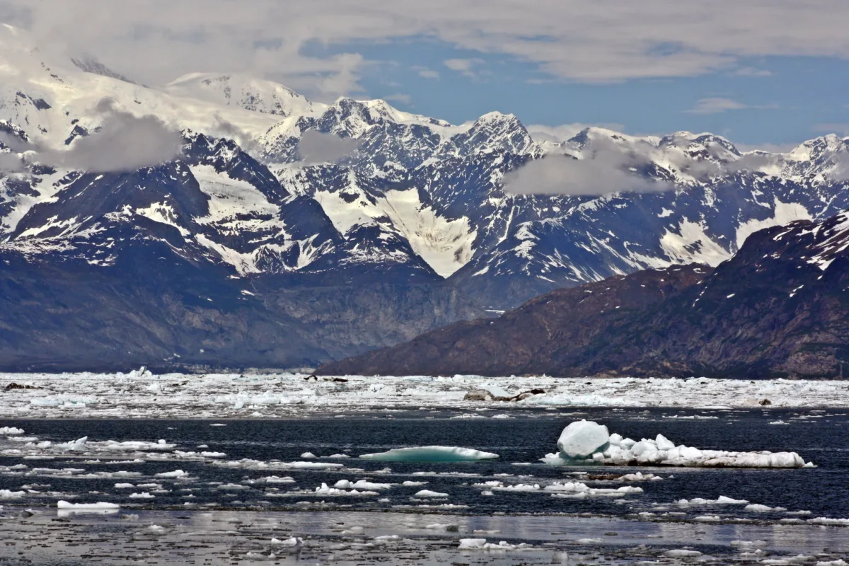
The Arctic is warming at more than twice the rate of the rest of the globe as a result of dramatic climate change, so the effects that come as a result are impactful up there. The cycle of the seasons and their durations shifts, making longer and hotter summers and shorter and warmer winters. In conjunction with this, things like rain storms and wind are likely to become more frequent and intense. Within these are very rapid, unexpected effects on ocean movements, like tide heights and intensity of waves, which can be dangerous for coastal civilizations and ecosystems. A recent paper by Sebin John and Michael West at the University of Alaska, Fairbanks uses seismic stations across Alaska and Canada to pick up tremors from ocean waves to understand the impacts of storms on sea ice.
Breaking the ice
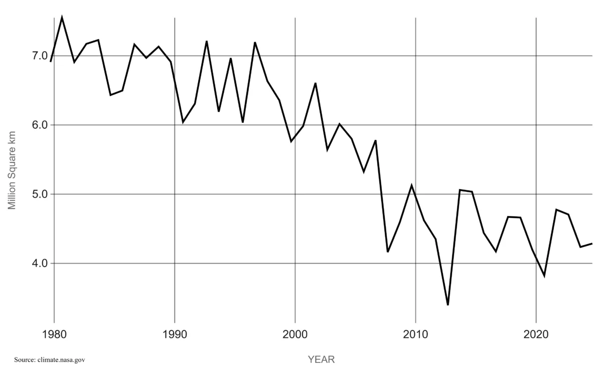
Arctic sea ice in particular has been a large area of concern—summer extent has been declining at a rate of 12% per decade since the 1980s. As global temperatures rise, a direct effect is this sea ice loss. Sea ice can protect coasts from erosion due to waves, particularly during storms. As that decreases, it can lead to erosion as these storms are able to beat against the coastlines. These storms are becoming more intense—when looking at the top 10 most extreme rainfall events in the US, nine of those have been since 1995—and on average, the total annual precipitation in the US increases at a rate of 0.18 inches per decade as well. So, the decreasing sea ice combined with ever increasing and unpredictable storm patterns due to climate change pose a large threat, making monitoring the ocean’s directional movements and waves heights more important.
A sound idea
In order to do this, the research team utilized a type of seismic noise called microseisms. As waves interact with each other and the ocean floor, small vibrations are produced that can be picked up by seismometers. By connecting storm behavior and sea ice concentration—the percentage of water covered by ice—to microseisms, patterns can be identified to predict future behavior.
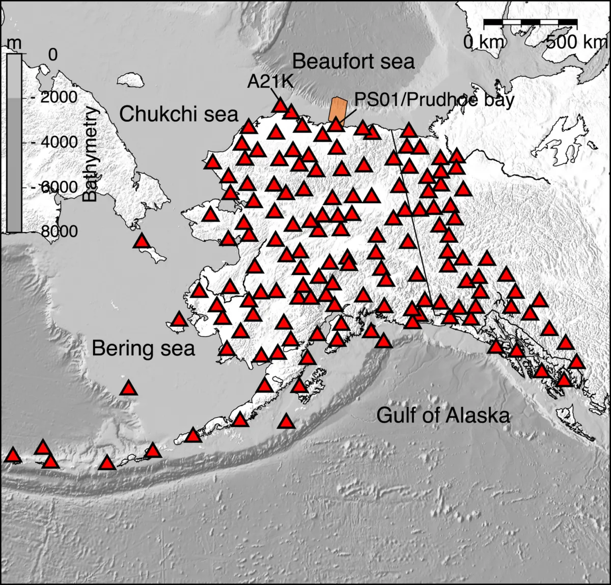
The research group used 155 seismic stations all across Alaska and part of Canada to listen for microseism from the Gulf of Alaska, the Bering Sea, the Chukchi Sea, and the Beaufort Sea. By selecting these specific ones in the already existing network that were nicely distributed all over the area, they can get a good spatial representation of how waves and storm activity affect the whole region.
They used the NSF SAGE data archive, dissecting the frequency of the energy sensed by the stations. The team was able to identify the microseism signal using the Power Spectral Density approach and link it to the waves occurring in nearby seas.
There are two types of noises or energy created that the team focused on—one mainly on the seafloor and one on the shoreline. The energy from the one of the seafloor is the main component in background seismic vibrations as wind-driven ocean storms hit the seafloor. The shoreline interactions give very small and localized energy compared to the seafloor ones. The seafloor and shoreline microseisms have periods of 5-10 seconds and 1-2 seconds, respectively. By looking at the noises captured by the seismometers over the past two decades or so, they could categorize and correlate them to wave heights measured during past storms.
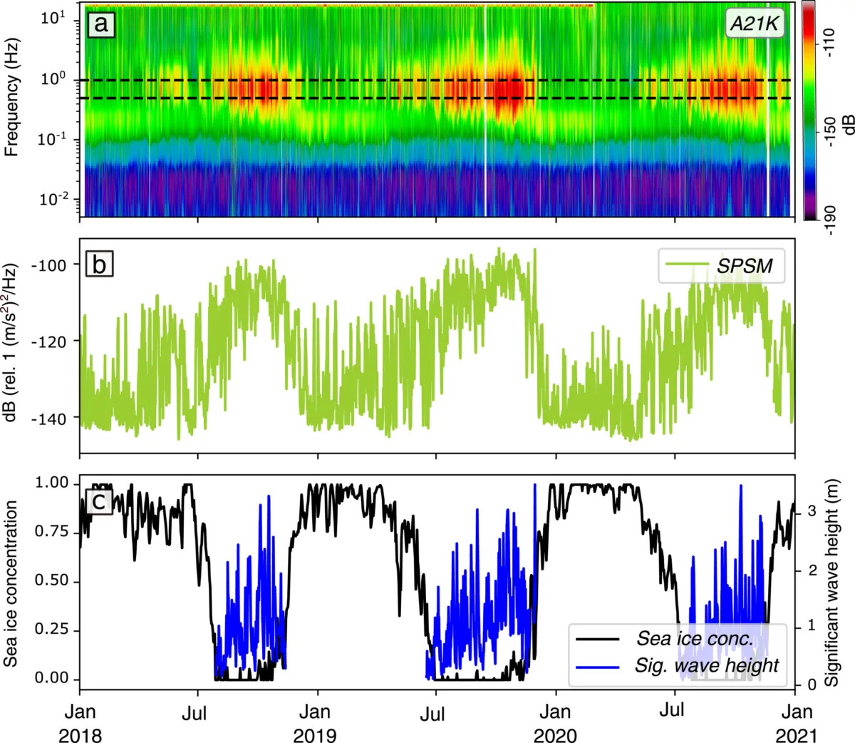
They were able to identify the Gulf of Alaska as the largest source of the seafloor microseisms by looking at the energy created by individual storms. They were also able to see the two microseisms in sync with each other during most storms in Southern Alaska. In the north, as sea ice encroaches early in winter, the shoreline energy decreases since there’s more sea ice present—seafloor was dominant in summer, but shoreline was dominant in winter.
Linking the microseismic energy to the storm history confirms that this kind of data from seismic stations all over Alaska can be used to track intensity and frequency of storms over time. They can also track the waves that can break up the sea ice. They were also able to see that as it got closer to colder months and the ice got denser, the microseisms sensed were extremely small, as waves were being blocked by the ice.
When looking at the patterns over time, however, they observed another effect of global warming. They saw some strong seafloor energy being created by waves that they hypothesize are the result of the coastal winds created from large temperature differences between on- and off-shore. If global temperatures continue to increase, not only will sea ice be more susceptible, but more intense storms and winds could be created, causing more waves and even more sea ice damage and, eventually, shoreline erosion. Compounding these two poses a large threat to sea ice, an important barrier between incoming waves and shorelines.
Through an existing network of seismic stations, this team was able to take seismic data—traditionally used to study earthquakes—and adapt it for looking at climate change and sea ice breakup. As sea ice continues to shrink as the global temperatures rise, waves can get larger and more powerful, putting coastlines at risk. This type of research can help to better understand the connections between storms, sea ice, and shoreline erosion. The team notes that this could also have further applications for sea ice rigidity, typhoon strength, and decadal-scale changes in ocean waves in the future. The Arctic is feeling the effects of climate change faster and more intensely, and those effects aren’t localized and will eventually directly impact the rest of the world. Work like this represents a larger goal of monitoring and protecting fragile and vulnerable environments.