

On March 28, 2025, a magnitude 7.7 earthquake struck near the city of Mandalay, in Myanmar. This strike-slip event occurred on the right-lateral Sagaing Fault. This means that one side of the fault moved horizontally past the other.
A recently released video has been circulating on social media that’s supposedly the first to capture surface rupture in action.
A magnitude 6.7 aftershock that struck to the south of the mainshock occurred 11 minutes later; major aftershocks can exacerbate the aftermath of a major earthquake. The toll includes more than 3,000 deaths and thousands of injuries. This event also caused a high-rise building under construction in Thailand, about 1,000 kilometers away, to collapse.
A study published in Geophysical Journal International about a month prior to the earthquake, led by Israporn (Grace) Sethanant, looked at the hidden seismic hazards within the Golden Triangle region of Laos, Thailand and Myanmar. The authors note how difficult mapping active faults in this region can be, in stark contrast to the Sagaing fault, which is well known, well mapped, and pronounced in the topography.
The team uses different methods to explore several earthquakes in detail that occurred between 2019 and 2023 in the Golden Triangle region. With that information, they discuss estimates of the thickness of the earthquake-producing portion of Earth’s crust in this region—a key metric for understanding seismic hazard.
Tectonics of the Golden Triangle
The northwestern horn of Thailand, northern Laos, and the eastern protuberance of Myanmar form the Golden Triangle. The mountainous region’s nickname was coined in the 1970s, and is a place known for its tourism and opium production.
The Golden Triangle sits on the Shan Plateau, which is bordered to the west by the Sagaing Fault—the host of the 2025 March Mandalay mainshock. The north-south trending Sagaing Fault, along with the Indo-Burma subduction zone, forms the system that accommodates the eastern edge of India’s northward collision into Eurasia.
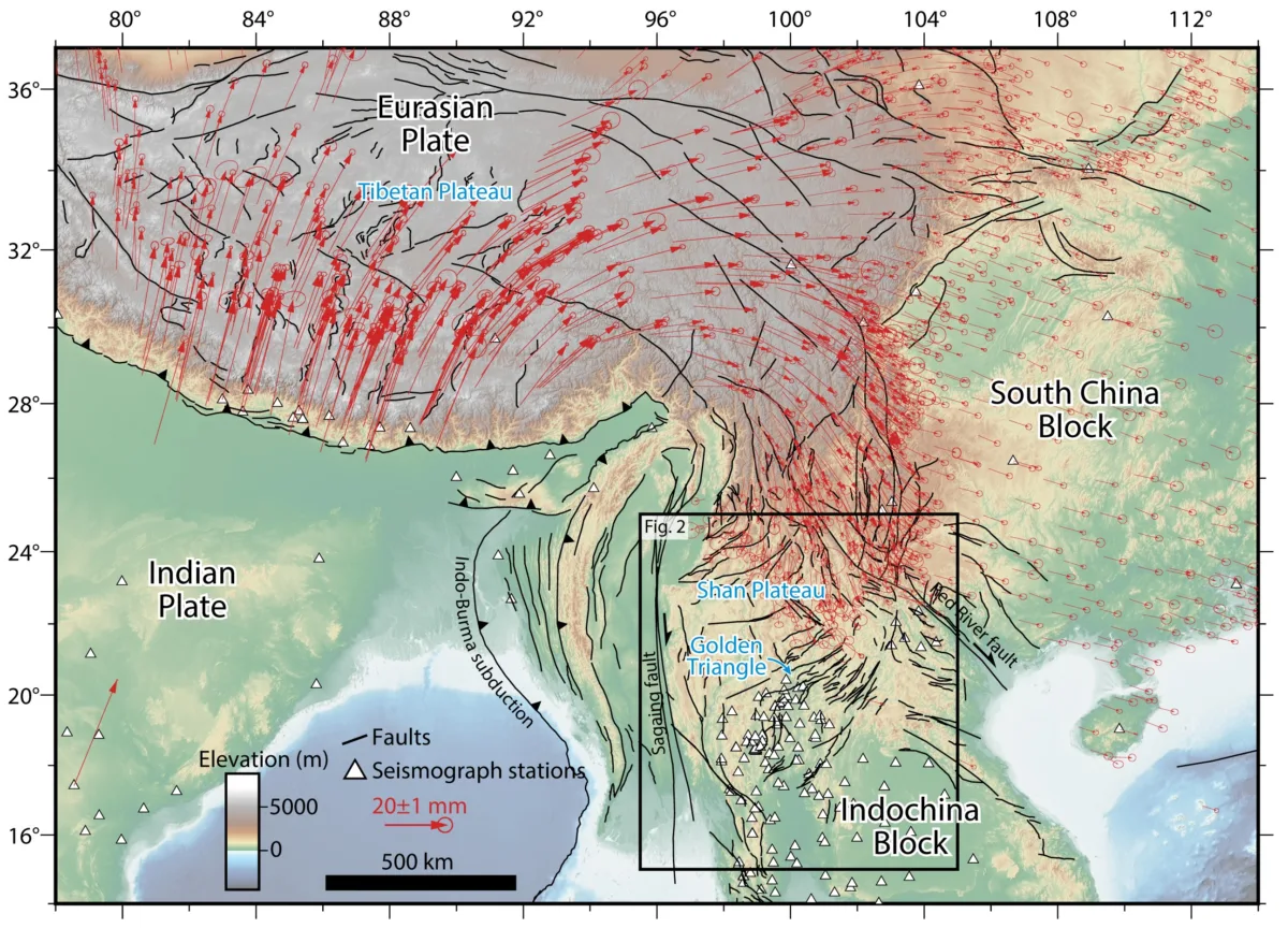
To the north and east, the Shan Plateau is separated from the South China block by the northwest-southeast-trending right-lateral Red River Fault.
An array of northeast-trending arc-shaped left-lateral faults cross the Shan Plateau. GPS/GNSS station velocities indicate that these faults account for about 12 millimeters per year of shear as the Shan Plateau moves relative to the southerly Indochina Block (home to Vietnam, Cambodia, and parts of Thailand). However, faults can be hard to map in the Golden Triangle because they may not be obvious in digital topographic maps, obscured by vegetation or perhaps eroded away.
Major quakes of the Shan Plateau
On the Shan Plateau, at least twenty magnitude 6.0 or greater earthquakes have been recorded since the early twentieth century, highlighting the seismic hazard in this region. Unfortunately, details like culprit faults are lacking for many of these quakes. This dearth of information stems from few seismic instruments deployed in this region, coupled with dense forests masking the surface from view of satellites.
In this study, Sethanant and colleagues focus on five major earthquakes that can be grouped into two regions. The Sainyabuli province of western Laos experienced a magnitude 6.2 earthquake in November of 2019, preceded by a magnitude 5.7 foreshock. The mainshock was felt widely in Laos, Thailand, Myanmar, Vietnam and southern China. Of bigger concern: The earthquake occurred about 40 kilometers from the Sainyabuli hydroelectric dam on the Mekong River. The ancient city of Luang Prabang, a UNESCO World Heritage Site, also experienced shaking from the earthquake. In December of 2021, a magnitude 5.5. event struck the same region, and is considered an aftershock of the November 2019 event.
North of the Sainyabuli region, and still atop the central Shan Plateau, lies the Keng Tung province of Myanmar; this is the second region of the study’s focus. In July of 2022, a magnitude 5.9 earthquake struck a previously unmapped fault that’s related to the Wan Ha Fault; in November of 2023, a magnitude 5.7 event struck another unmapped fault approximately 60 kilometers to the west of the 2022 event, Sethananth says.
Exploring earthquakes
For this study, Sethanant and colleagues approached the problem of understanding past events by using two types of data: geodetic (or satellite) data, and seismic data. Satellite data helps capture slip that happened near the surface during the rupture—the coseismic slip. Seismic data marks where—at depth—an earthquake began and how it propagated through Earth’s crust.
The team mapped surface deformation using Synthetic Aperture Radar (SAR) data, acquired by the European Space Agency’s Sentinel-1A/1B satellites. “We were able to locate the fault, estimate how much the ground moved, and model the size of the fault plane (length, width, depth) for the 2019, 2021, and 2022 events,” Sethanant says. The 2019 and 2021 events occurred in the Sainyabuli province, and the 2022 event occurred in the Keng Tung province. Only the November 2019 magnitude 6.2 Sainyabuli earthquake exhibited enough deformation for inverse modeling of the satellite data.
The team also used seismic waveform data from the NSF SAGE archive operated by EarthScope; earthquake arrival times came from several sources. With seismic data, the team relocated hypocenters for both sets of earthquakes and their largest aftershocks. Relocation calculations better refine where the earthquake started, Sethanant explains.
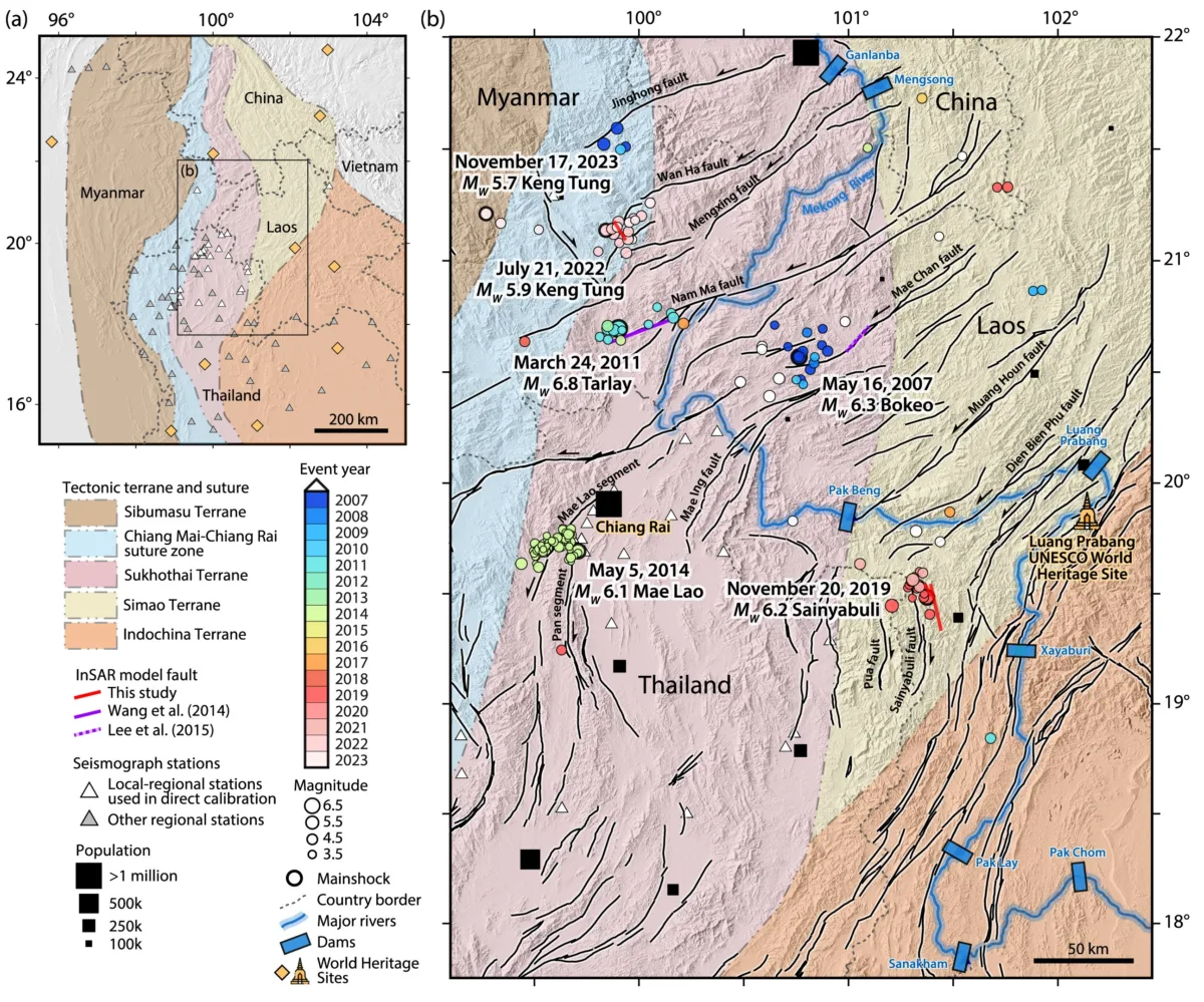
A total of 158 earthquakes spanning the southern and central Shan Plateau were relocated in what Sethanant and colleagues call the Golden Triangle cluster. This cluster of relocated events includes earthquakes from other sequences prior to 2019.
The team also used the seismic data to estimate moment tensors (beachball diagrams) for all five specified earthquakes. With this information, they could explore where slip is concentrated, which serves as a check against the InSAR modeling, she says.
Deep nucleation, shallow slip?
With these methods, Sethanant and colleagues explored each rupture in as much detail as the data allow. For example, for the 2019 Sainyabuli magnitude 6.2 mainshock, analysis of the satellite data indicated that slip was concentrated at depths between 3 and 7 kilometers. This is known as the peak slip. Analysis of the moment tensor indicates motion at a depth of 4 kilometers. On the other hand, relocation via seismic data places the hypocenter at a depth of about 12 kilometers. “Relocation provides a better constraint on the focal depth,” Sethanant says. The focal depth is the depth at which an earthquake initiates.
The authors made similar observations from the other events analyzed in this study. They note that this may imply that slip tends to propagate upward. In this scenario, relocation provides the depth of nucleation, and the information gleaned from the moment tensor and satellite data tell us how slip evolved.
“These discrepancies between deep hypocentres and shallow coseismic slip,” write the authors, “may reflect a tendency for earthquakes to nucleate within a creeping zone near the base of the seismogenic layer.” They note that previous studies have seen similar features for other earthquakes, like the 2014 magnitude 6.1 Napa, California earthquake.
Other notable events
Sethanant and colleagues also examined other notable earthquakes, like the 2011 magnitude 6.8 Tarlay, Myanmar earthquake the killed at least 74 people and impacted at least 18,000 people. The left-lateral event, with a 30 kilometer-long surface rupture, may have initiated at a depth of 15 kilometers, according to Sethanant. Aftershocks occurred deeper than where satellite data suggests that slip concentrated.
By examining the catalog of relocated earthquakes, the authors found that 90 percent of earthquakes occur within a depth of 17 kilometers in Earth’s crust, consistent with the locking depth (derived geodetically), which ranges from 10 to 21 kilometers in this region. This observation suggests that the seismogenic layer—the brittle part of the crust that can sustain seismic rupture by breaking, and so producing earthquakes—is of intermediate thickness compared to other continental plate boundary zones.
Putting the five studied quakes in this context, the authors note that in particular, the 2019 magnitude 6.2 Sainyabuli earthquake and the 2022 magnitude 5.9 Keng Tung earthquake only ruptured the upper half of the seismogenic layer. This may indicate that the lower, unruptured half poses a seismic hazard.
Additionally, they identified at least three new faults, which must be mapped and incorporated into seismic hazard analysis of the region. Detailed fault mapping and paleoseismic investigations would help. The team concludes that across the Shan Plateau, short, hidden, likely immature faults can generate earthquakes of significance. These faults, they write, “should not be overlooked… especially for the designing and retrofitting of nearby hydroelectric dams and cultural sites.”