

The island of Taiwan may be better known for earthquakes than eruptions, but volcanoes shape this land, and they may not be entirely asleep.
The Tatun Volcano Group rises near the Taipei metropolitan area — home to more than 7 million people. Though no record exists of eruptions in human history, recent seismicity indicates that these volcanoes might be growing restive.
In a new paper published in Scientific Reports, a team from Taiwan presents a 4-dimensional seismic tomography model that explores both the temporal and spatial variations in seismicity. How has seismicity changed in both time and space?
Results suggest a dramatic increase in seismicity in 2019 on the heels of a change in seismic velocity below the Mt. Chihsin region. This change, the authors argue, may result from higher pressure beneath the Tatun Volcano Group. They note that careful monitoring of the area may provide early warning of potential volcanic activity.
A volcano in the distance
Mt. Chihsin is the highest peak of the Tatun Volcano Group, which consists of about 20 volcanoes that shape the northernmost part of Taiwan. Mt. Chihsin volcano, a mere 15 kilometers from Taipei, produced the most recent eruption. In fact, the northernmost sections of the city are built atop the volcano itself.
Radiocarbon dating of volcaniclastic deposits suggests that the last eruption occurred about 6,000 years ago. Other work uses different lines of evidence to suggest that the last eruption was even more recent — possibly 1,350 years ago. Additionally, multiple studies have used seismic data to detect and confirm a magma reservoir residing in the middle crust.
Taken together, this information implies that the Tatun Volcano Group may be active. Considering its proximity to Taipei, disaster prevention and mitigation measures are critical issues.
Seismicity on the volcano
The Taiwan Volcano Observatory at Tatun keeps watch over what’s happening. For example, since 2003, a dense seismic array of 40 broadband stations has gradually been deployed. These stations, meant to monitor volcanic activity, have detected many microearthquakes.
Between 2014 and 2018, more than 1,000 shallow earthquakes occurred beneath the Dayoukeng fumarole, which lies east of Mt. Chihsin. Fumaroles are vents that emit steam and volcanic gases. Based on the earthquakes’ locations, they outline what appears to be a conduit. Additionally, scientists have also detected heartbeat-like earthquake sequences. These observations — the conduit and quakes — point to a possible pathway for an eruption.
Since 2019, earthquakes again increased in both magnitude and frequency. Most earthquakes greater than magnitude 3 were concentrated around the Dayoukeng fumarole and Mt. Chihsin. The team used seismic data collected by the Taiwan Volcano Observatory between 2014 and 2021 (analyzed with the help of the NSF SAGE-supported Seismic Analysis Code) to explore the velocity structure beneath the volcano.
Structures below the surface
Seismic velocity changes beneath the surface can reveal information about structures that we would otherwise have no way of seeing. Seismic tomography exploits seismic waves — and changes in their velocity — to image the structures of Earth’s interior. Add the dimension of time, and scientists can track how Earth’s insides are changing, which is of particular value in a volcanic region.
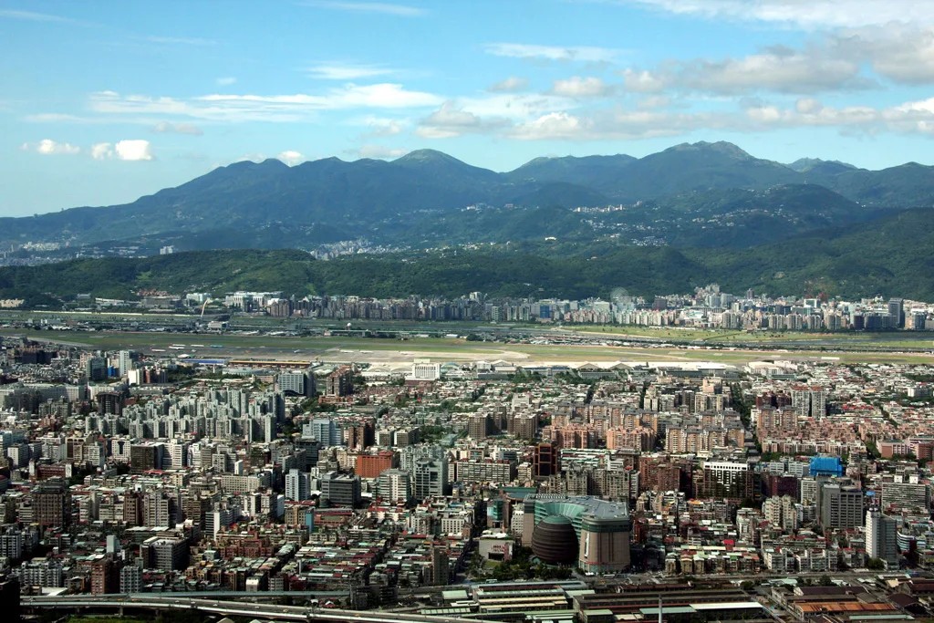
Among their findings, the authors of the paper found perturbations beneath the Dayoukeng fumarole. The most prominent anomaly observed is a nearly vertical channel extending from sea level to a depth of three to four kilometers beneath the fumarole. The clearest expression of this channel came from velocity differences between 2017 and 2018.
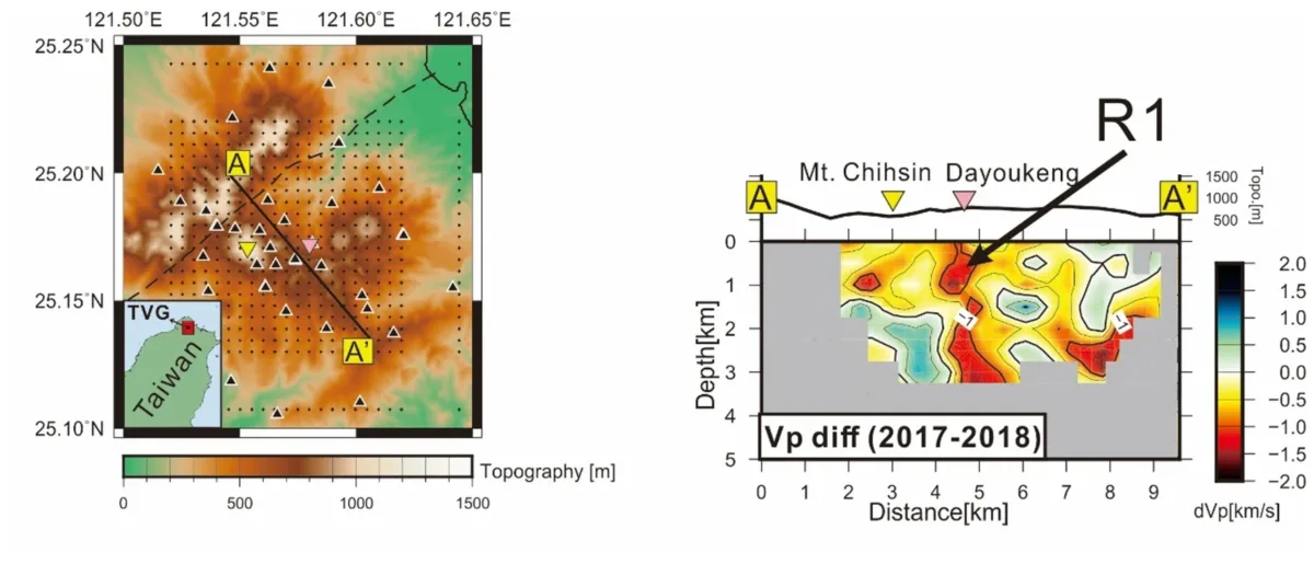
The team also explored what might be happening beneath Mt. Chihsin itself. They found that in all years, a major anomaly appears at depths of three to four kilometers beneath the mount. The anomaly is most clear in the velocity difference between 2017 and 2018. The coincidence of a change in P-wave velocity followed by the 2019 increase in seismicity suggests that these observations could be linked.
The pressure cooker
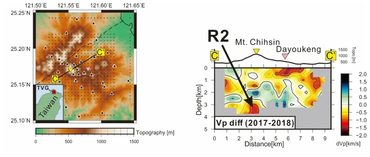
In the authors’ preferred interpretation, in 2014, stable degassing was ongoing via both the fumarole and Mt. Chihsin. “Earthquake activity is largely confined to clustering within the pathway itself,” they write. For monitoring purposes, clusters of seismic events could indicate degassing zones and demarcate volcanic pathways.
Between 2015 and 2018 — when the authors observed a change in P-wave velocity — the top of the conduit may have gradually sealed, increasing the confining pressure. Changes in P-wave velocity could also result from changes in temperature, rock composition or water content. A change in confining pressure, the authors note, may be like a pressure cooker being heated as volcanic fluids ascend from a deep magma reservoir. The seal itself may have formed as clay-rich rocks accumulated in the upper levels of the conduit — the result of rock-fluid interaction. Earthquakes that rumbled the surrounding areas may be explained by stress associated with this inflation.
From 2019 to 2021, strong seismicity — earthquakes with magnitudes greater than 3 — may have broken the seal, “similar to a pressure cooker explosion.” Seismic swarms unexpectedly occurred in and around the pathway as well. In this scenario, seismicity, seismic velocity and confining pressure would return to a stable state in which the main conduit is defined by seismicity — like prior to 2014. By monitoring not only seismicity, but also seismic velocity changes across the Tatun Volcano Group, scientists may be better able to track potential volcanic activity. In particular, they could look for sequential changes in these two observables. Most importantly, tracking these changes could, according to the authors, facilitate early warnings for strong seismic swarms or potential volcanic activity. Early warnings can save lives, particularly in a place as populous as Taipei.