

For all the unique beauty on display in the landscape of Yellowstone National Park, there is also enduring public and scientific interest in what lies beneath. It’s Yellowstone’s magmatic guts that both make it a sight-seeing destination and a significant volcanic hazard. Fortunately, we aren’t limited to simply guessing what might be going on down there―geophysics lets us look.
Just as medical imaging can reveal what’s going on inside your body, there are geophysical tools we can use at the surface to see deep beneath Yellowstone. And just as we might use X-rays to imagine bones but an MRI to image soft tissues, different geophysical tools have different strategies.
Seismometers are commonly used in this way, as seismic waves are altered by the material they pass through along the way. Properties like density and temperature affect the velocity of the waves, for example. For imaging fluids like magma, magnetotellurics can excel because they are less sensitive to some of these other properties.
In a new paper published in Nature, a team led by the USGS’ Ninfa Bennington uses a dense array of magnetotelluric measurements to generate a high-resolution image of the melt beneath Yellowstone.
Mag-neato
Magnetotelluric instruments measure the electrical conductivity of the Earth based on natural electric and magnetic fields induced by energy from the Sun. Some frequencies sample deeper into the Earth than others, so with enough measurements in an array around an area, you can map out conductivity in three dimensions.
While the Magnetotelluric Array project gradually mapped out the entirety of the contiguous US, there is a lot of detail to be revealed by focusing data collection on a smaller area. In this case, the research team spent a pair of field campaigns deploying instruments at more than 100 locations around Yellowstone. Combined with the coarser resolution data of the Magnetotelluric Array, this allowed them to zoom in on the magma stored beneath Yellowstone.
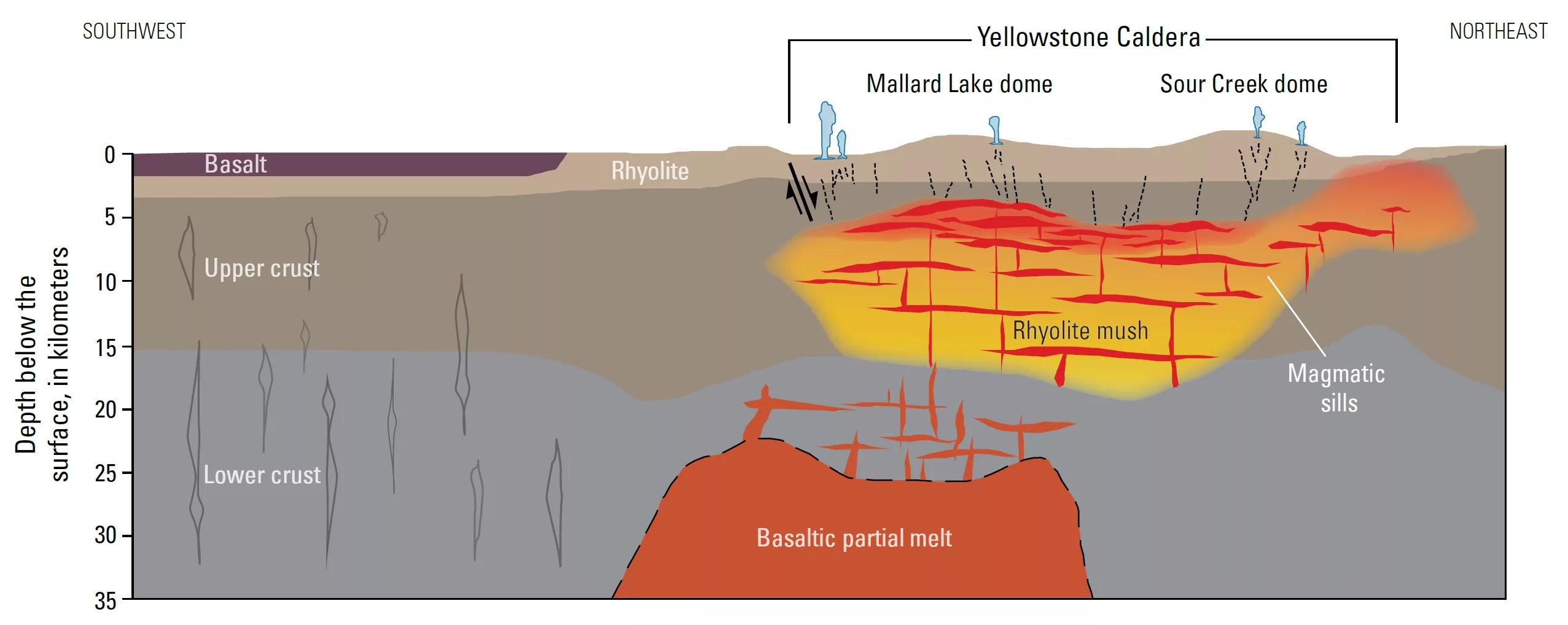
Many previous efforts have imaged this area using seismic data, which taught us quite a bit. Nearer the surface―at depths around 5 to 15 kilometers (3 to 9 miles)―viscous rhyolite magma has been detected. Farther down, in the lower part of the crust, there are signs of basalt magma. Neither of these are large “chambers” full of entirely molten rock. Instead, they are reservoirs of “crystal mush”―mostly solid crystals with some liquid magma in the spaces between them.
These reservoirs had some visible shape to them, but most of the imaging showed a continuous body of rhyolite storage beneath Yellowstone.
Several things jump out in the new magnetotelluric dataset. One is that the rhyolite magma reservoir is actually several separated, smaller reservoirs. Another is that only the reservoir just outside the northeastern boundary of the caldera appears to be connected to deeper basalt reservoirs.
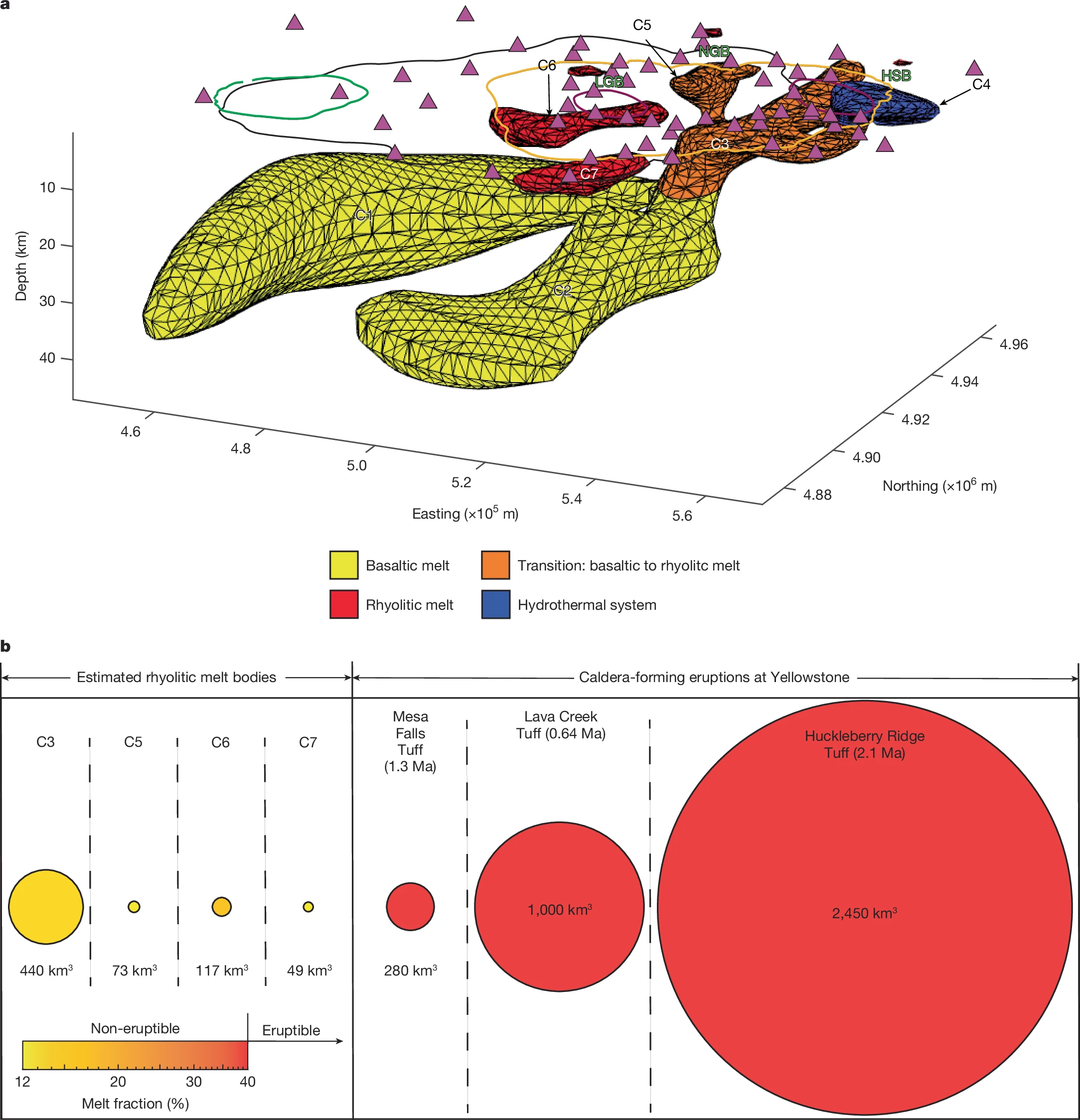
The data can also constrain what proportion of each reservoir is liquid melt vs. solid crystals, which then allows the total volume of melt to be calculated. Each fell between 9 and 15 percent melt, well below the proportion that allows for eruption. The northeast reservoir is by far the largest at about 440 cubic kilometers of melt. (For comparison, the most recent catastrophic caldera-forming eruption 640,000 years ago erupted about 1,000 cubic kilometers.)
Diagnostic imaging
Previous eruptions have followed a sequence, with a catastrophic caldera-forming eruption before many rhyolite lava flows and, finally, basalt lava flows in the caldera. The most recent sequence hasn’t spit out any basalt lavas, though, and it has been over 70,000 years since the last rhyolite lava flows. So one thing the team wanted to look for was evidence that Yellowstone might still be in one phase or another of that sequence.
The mostly solid rhyolite magma reservoirs, and lack of connections to underlying basalt in most areas, indicate that there’s no reason to think we’re still in the rhyolite-lava-erupting phase. But there also doesn’t seem to be basalt magma eager to erupt. It’s thought that the shallower rhyolite reservoirs block off basalt magma from ascending to the surface until they’ve completed cooled and are capable of opening fractures.
Looking forward, the imaging also indicates that the center of any rhyolitic activity has already shifted to the northeast edge of the caldera―continuing the long-lived trend as the North American plate moves over this mantle hot spot. Past volcanic activity stretches southwest of Yellowstone, forming Idaho’s Snake River Plain.
Smaller lava flow eruptions may often result from rejuvenated magma reservoirs. That is, mostly solid crystal mush reservoirs can be reheated by a fresh delivery of hot basalt magma underneath them. That increases the proportion of melt, which can migrate up through the mush and collect at the top of the reservoir. But only the northeast reservoir has a visible connection with a deeper basalt reservoir helping to keep it warm―which is also feeding heat into hydrothermal areas in the park.
The most common hazards in Yellowstone relate to these hydrothermal systems right near the surface, which can produce explosions of varying sizes. But the magnetotelluric imaging does not reveal large magma reservoirs that are currently capable of significant eruptions. What it does do is give us a clearer view of the state of Yellowstone’s innards. That’s a significant boon to research and to monitoring at this charismatic volcanic system.
The magnetotelluric data used in this study are stored in the NSF SAGE data archive operated by EarthScope.