Yellowstone National Park, though infamous for its past massive eruptions, is perhaps more traditionally famous for its spectacular geysers that send steam and water skyward. Geysers episodically erupt a mixture of water, vapor, and sometimes debris (like sand and mud).
Geysers bear similarities to volcanic eruptions, except that they tend to erupt more frequently and at smaller scales (and of course do not spout molten rock). Because of this likeness, learning about geysers can help scientists better understand volcanoes, which pose a greater societal threat.
Scientists use an arsenal of tools to monitor volcanoes, including seismometers, which can detect magma movement, interactions between magma and fluid, and acoustic signals from explosive eruptions. Though widespread for volcano monitoring, seismometers are not usually deployed to monitor geysers for any longer than a few days to weeks. In fact, few geysers are monitored well enough to understand basics like eruption timing.
Published in Geophysical Research Letters, a new study of Steamboat Geyser—the world’s tallest—explores a recording bias that was only apparent because its unique seismic dataset spanned several years. “We found that seismic signals from the eruptions appeared weaker in winter due to snow,” said lead author Mara Reed, a doctoral student at the University of California, Berkeley and former IRIS REU (now URISE) intern.
(In fact, Mara’s 2016 internship project centered on a geophysical study of a geothermal system in Idaho. “I was initially torn between pursuing astrophysics or geoscience—the IRIS experience cemented my path toward geoscience,” she said.)
Steamboat Geyser’s seismic signals
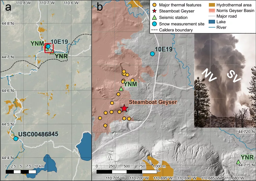
Steamboat Geyser, in Norris Geyser Basin of Yellowstone National Park, has intense eruptions powerful enough to generate seismic waves and acoustic waves. The acoustic waves are transferred into the ground, producing tiny ground motions. These signals, as well as the direct seismic signal that travels through the ground, are detectable by at least one of two nearby seismometers. These seismometers are part of the Yellowstone National Park Seismograph Network operated by the University of Utah Seismograph Stations, and the data are available via EarthScope.

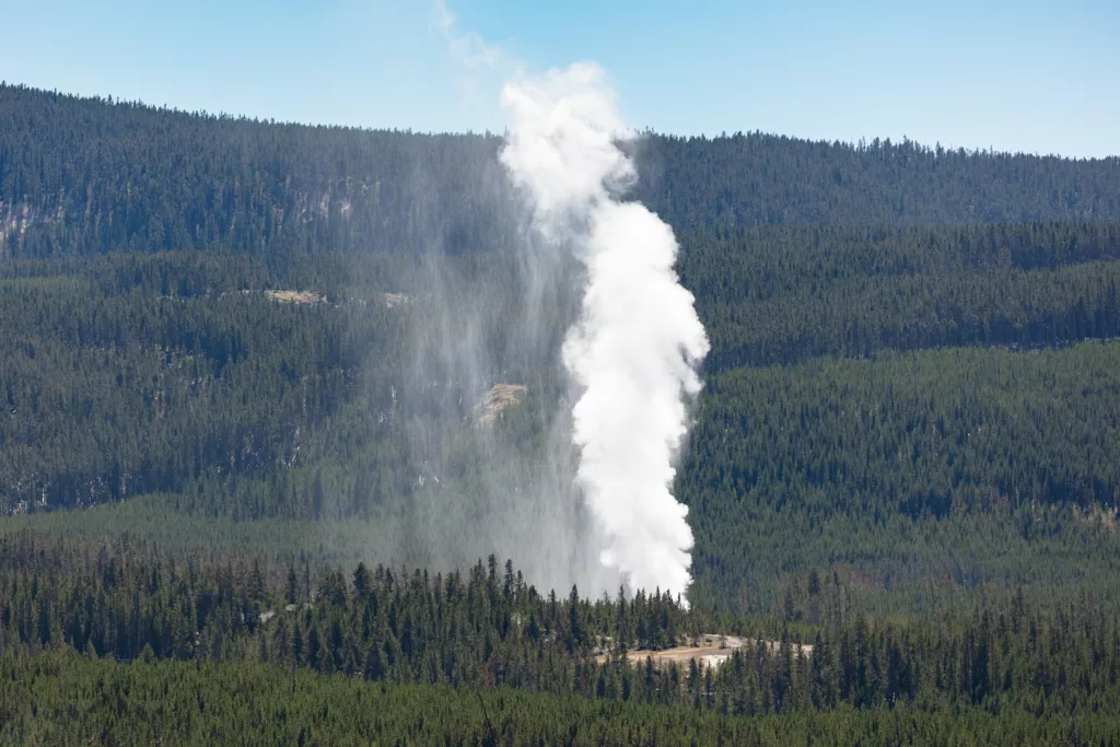
In March of 2018, the geyser entered an ongoing active phase with frequent, major eruptions occurring on the order of days to weeks apart. When major eruptions commence at Steamboat Geyser, two adjacent vents—the North and South Vent—participate. The North Vent dominates, reaching maximum heights of between 85 and 137 meters into the air—about as tall as a 30 story building. The South Vent reaches only about 50 to 70% as high. These jets erupt together for less than two hours, with water jetting upward and then falling back to Earth. As the skyward spout of water gradually subsides, steam takes over. The steam phase can last hours to days, but always abates as the vents rejuvenate in preparation for the next eruption. Minor spurts of water less than about 15 meters high from one or both vents punctuate the time between major eruptions.
Because of the rarity of Steamboat Geyser’s towering major eruptions, the recent activity attracted many passersby—from tourists to geyser enthusiasts. GeyserTimes is a crowdsourced database of eruptions that contains a complete catalog of eruption start times, reported by observers or inferred from publicly available monitoring data. For instance, in addition to the seismometers, a runoff channel temperature logger maintained by the Yellowstone Volcano Observatory measures the hot water flowing away from the vent, helping to track activity.
Though this eruptive activity has continued into 2023, Reed focused her efforts on 147 eruptions that occurred between 2018 and 2021. It is within these data that she and her coauthor and doctoral advisor, Michael Manga, noticed something peculiar—the magnitude of the seismic signals showed seasonal variations, with winter’s eruptions seeming much weaker. But did this result from seasonal changes in the eruptions output, or was something else suppressing the signal?
Surprising snow signal
To explain their unexpected observation—that winter’s seismic signals from Steamboat Geyser are puny compared to summer’s—Reed and Manga decided to check snow depth.
However, the ground at Norris Geyser Basin can be warm enough to prevent snow accumulation in some places, and Steamboat Geyser does not have a weather station that records daily snowfall. Instead, they had to use snow depth from the nearest weather station, located about 30 kilometers away near Old Faithful, as a proxy for snow depth at the seismic stations used in this study.
They found that for the nearest seismic station located about 340 meters away from Steamboat Geyser, signal power decreased as snow depth increased. “Each eruption is different,” said Reed. “There is some intensity variation between eruptions, but the correlation between snow depth and seismic amplitude is strong.”
Why snow, and why seismoacoustic waves?
If the seismic signals were dominated by waves traveling through the ground, then snow depth shouldn’t matter, said Reed. “To see what kind of signal we were getting, we took advantage of both seismometers’ data.” By comparing the similarity of the signals, Reed calculated how much longer it took the signal to reach the far seismometer, also called the time delay. “That time delay was consistent with waves traveling at the speed of sound through air.” If this is the case, then the acoustic waves produced by the eruption—comparable to the low roar of a jet engine—have a layer of snow through which to penetrate before arriving at the sensor. This can decrease the power of the signal, which is what the scientists see.
Interestingly, although high frequency bands show decreased signal size at both seismic stations used in this study, this isn’t true for all bands. For the nearer of the two seismic stations, the signal remains at the same power regardless of snow level for certain low frequencies, implying that there’s a different process at play. “This signal stumped us a bit,” acknowledged Reed. “It emerges tens of seconds later than the other signals and probably travels only through the ground. We think it might be generated by pressure perturbations in the geyser’s conduit, but more work needs to be done to confirm that.”
Volcano problems
Although the finding that these smaller signals result from snow depth and not seasonality of the geyser itself is interesting on its own, it also highlights that the relative strength of ground motions should not be used to determine the intensity of geyser eruptions. Moreover, this study also implies that for volcanoes with snow covering their sensors, attenuation of seismoacoustic signals may be a problem.
More long-term monitoring studies like this one are needed to better understand these and other biases that could be missed during short, sporadic studies. Yet, few geysers around the world are monitored for long stretches of time. Reed is excited for Yellowstone’s first co-located seismometer and infrasound sensor to be permanently installed within Norris Geyser Basin later this year. “To be able to learn about how geysers work, to learn how and why they change, to identify what factors might bias data collection and interpretation—all things that have strong potential relevance for volcanoes—we need baselines for geyser activity. And we can only get that through long-term monitoring.”

