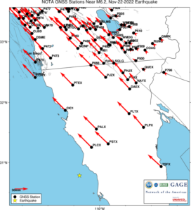
Stations within the 254 km radius of predicted 1 cm displacement.
GNSS data access tools can be found here. The Event Data Access notebook can be used to locate stations nearest this event.


Location: ...°, ...°
Depth: ... km
At 16:39:05 (UTC) on November 22, a magnitude 6.2 earthquake occurred 29 km southwest of Las Brisas, Mexico. For more information, see the USGS Earthquake Hazards Program event page.

Nearest GNSS stations
Stations within the 254 km radius of predicted 1 cm displacement.
GNSS data access tools can be found here. The Event Data Access notebook can be used to locate stations nearest this event.
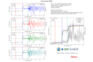
B088 borehole strain
Borehole strainmeter data at station B088, 288 km from epicenter.
High-rate data from borehole strainmeters can be accessed here.
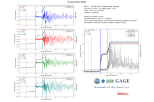
B093 borehole strain
Borehole strainmeter data at station B093, 313 km from epicenter.
High-rate data from borehole strainmeters can be accessed here.
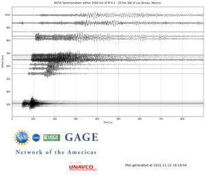
The event occurred within the footprint of the Network of the Americas (NOTA), a network of continuous GPS/GNSS stations and borehole instruments operated by UNAVCO that monitors plate motion and transient deformation, in addition to other applications. Stations near the event for which UNAVCO delivers data include a number of REGNOM/CICESE stations and one IGS station. Use of data from all stations should be acknowledged appropriately.